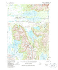
1950 Map of Cordova B-2
USGS Topo · Published 1988About this map
The Copper River Delta State Critical Habitat Area dominates the landscape of this mid-century survey, where the intricate hydrology of Mirror Slough and the Martin River meet the towering peaks of the Chugach Mountains. The map documents a period of transition in coastal Alaska, preserving the path of the Old Railroad Grade as it cuts through the Chugach National Forest near the Katalla River. Remote outpost life is evidenced by the presence of a Cabin and the Bennett Rock Cabin, providing specific points of interest for researchers of territorial history. The geography is defined by significant freshwater bodies, including Martin Lake and Little Martin Lake, nestled against the foothills. This survey offers a clear view of the delta's complexity before late-century shifts, charting the confluence of Clear Creek and Sheep Creek within this protected wilderness corridor.
Find a feature on this map
14 named features on this map. Tap any name to fly to it.
Don’t see what you’re looking for? This feature index may not catch every label — zoom into the map to look around manually.
Map Details
Editions of this 1950 Cordova B-2 Map
4 editions found
Other maps of this area

1948 · Cordova
USGS Topo · 1:250,000

1950 · Cordova B-2
USGS Topo · 1:63,360

1950 · Cordova A-1
USGS Topo · 1:63,360

1950 · Cordova A-2
USGS Topo · 1:63,360

1951 · Cordova
USGS Topo · 1:250,000

1951 · Cordova B-1
USGS Topo · 1:63,360

1951 · Cordova C-3
USGS Topo · 1:63,360

1952 · Cordova B-3
USGS Topo · 1:63,360

1953 · Cordova A-2
USGS Topo · 1:63,360

1953 · Cordova B-1
USGS Topo · 1:63,360