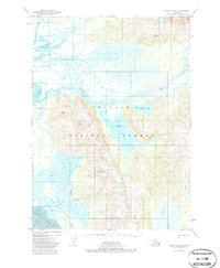
1950 Map of Cordova B-2
USGS Topo · Published 1985About this map
Martin Lake and the winding channels of the Martin River dominate this coastal Alaskan landscape within the Chugach National Forest. Surveyed in the mid-20th century, the map reveals a wilderness shaped by high glacial peaks like those in the Chugach Mountains and complex hydrological networks including Little Martin Lake and the Martin River Slough. The presence of isolated outposts such as Bennett-Rock Cabin and a lone Cabin near the lakeshore suggests a landscape primarily accessed by water or air, used for seasonal trapping, hunting, or forest management.
Find a feature on this map
16 named features on this map. Tap any name to fly to it.
Don’t see what you’re looking for? This feature index may not catch every label — zoom into the map to look around manually.
Map Details
Editions of this 1950 Cordova B-2 Map
4 editions found
Other maps of this area

1948 · Cordova
USGS Topo · 1:250,000

1950 · Cordova B-2
USGS Topo · 1:63,360

1950 · Cordova A-1
USGS Topo · 1:63,360

1950 · Cordova A-2
USGS Topo · 1:63,360

1951 · Cordova
USGS Topo · 1:250,000

1951 · Cordova B-1
USGS Topo · 1:63,360

1951 · Cordova C-3
USGS Topo · 1:63,360

1952 · Cordova B-3
USGS Topo · 1:63,360

1953 · Cordova A-2
USGS Topo · 1:63,360

1953 · Cordova B-1
USGS Topo · 1:63,360