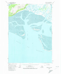
1951 Map of Cordova B-5
USGS Topo · Published 1973About this map
Heney Range and the prominent Mount Robert Korn dominate the northern landscape of this coastal region, where steep mountains descend into a complex network of mudflats and tidal channels. Surveyed in the early 1950s, the map reveals a dynamic shoreline defined by the massive outflow of the Eyak River and Government Slough. Inland, the terrestrial environment is marked by Crystal Falls and a small cluster of cabins located near a mountain trail, suggesting small-scale seasonal habitation or subsistence activities in the shadow of the peaks.
Find a feature on this map
24 named features on this map. Tap any name to fly to it.
Don’t see what you’re looking for? This feature index may not catch every label — zoom into the map to look around manually.
Map Details
Editions of this 1951 Cordova B-5 Map
3 editions found
Other maps of this area

1948 · Cordova
USGS Topo · 1:250,000

1950 · Cordova C-6
USGS Topo · 1:63,360

1950 · Cordova C-4
USGS Topo · 1:63,360

1951 · Cordova
USGS Topo · 1:250,000

1951 · Cordova B-4
USGS Topo · 1:63,360

1951 · Cordova C-5
USGS Topo · 1:63,360

1951 · Cordova B-5
USGS Topo · 1:63,360

1951 · Cordova B-6
USGS Topo · 1:63,360

1953 · Cordova C-6
USGS Topo · 1:63,360

1953 · Cordova B-5
USGS Topo · 1:63,360