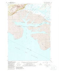
1951 Map of Cordova B-5
USGS Topo · Published 1988About this map
The Copper River Delta dominates this coastal survey, revealing a complex aquatic network where glacial runoff meets the Gulf Of Alaska. Most of the land is protected within the Copper River Delta State Critical Habitat Area and the Chugach National Forest, which includes the prominent Mount Robert Korn. The landscape is defined by its shifting hydrology, including the Eyak River and a series of drainage features like Alaganik Slough, Government Slough, and Eyak Slough. Small signs of human presence are sparse, indicated only by Cabins along the river banks. This survey captures a dynamic coastal environment where Copper Sands and Egg Island Channel mark the interface between the mainland and the open sea.
Find a feature on this map
20 named features on this map. Tap any name to fly to it.
Don’t see what you’re looking for? This feature index may not catch every label — zoom into the map to look around manually.
Map Details
Editions of this 1951 Cordova B-5 Map
3 editions found
Other maps of this area

1948 · Cordova
USGS Topo · 1:250,000

1950 · Cordova C-6
USGS Topo · 1:63,360

1950 · Cordova C-4
USGS Topo · 1:63,360

1951 · Cordova
USGS Topo · 1:250,000

1951 · Cordova B-4
USGS Topo · 1:63,360

1951 · Cordova C-5
USGS Topo · 1:63,360

1951 · Cordova B-5
USGS Topo · 1:63,360

1951 · Cordova B-6
USGS Topo · 1:63,360

1953 · Cordova C-6
USGS Topo · 1:63,360

1953 · Cordova B-5
USGS Topo · 1:63,360