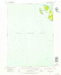
1952 Map of Cordova C-8
USGS Topo · Published 1954About this map
Prince William Sound dominates this mid-century hydrographic and topographic study, showing the deep-water soundings and coastal elevations of the northern gulf. This portion of the Chugach National Forest is characterized by its complex shoreline, where the waters of Snug Corner Cove meet the jagged edges of Porcupine Pt. The map provides specific maritime detail, including the exact location of Cabins on the northern tip of Goose Island, offering a look at small-scale seasonal or permanent settlement in this coastal region.
Find a feature on this map
8 named features on this map. Tap any name to fly to it.
Don’t see what you’re looking for? This feature index may not catch every label — zoom into the map to look around manually.
Map Details
Editions of this 1952 Cordova C-8 Map
2 editions found

Other maps of this area

1948 · Cordova
USGS Topo · 1:250,000

1950 · Cordova C-7
USGS Topo · 1:63,360

1950 · Cordova B-7
USGS Topo · 1:63,360

1950 · Cordova D-7
USGS Topo · 1:63,360

1950 · Cordova C-8
USGS Topo · 1:63,360

1951 · Seward
USGS Topo · 1:250,000

1951 · Cordova
USGS Topo · 1:250,000

1951 · Seward B-1
USGS Topo · 1:63,360

1951 · Seward D-1
USGS Topo · 1:63,360

1951 · Cordova D-8
USGS Topo · 1:63,360