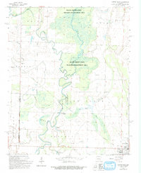
1968 Map of Cotton Plant
USGS Topo · Published 1993About this map
The Cotton Plant area of Woodruff County is defined by the winding course of the Cache River and its associated wetlands. Much of the central landscape is dedicated to the Black Swamp State Wildlife Management Area, where the river fragments into the Cache Bayou and Roaring Slough. These bottomlands are dotted with markers of local heritage, from the Indian Mound near Beard Cem to the crossing at James Ferry. The settlement pattern follows the higher ground around the swamp, connecting the communities of Maberry, Dixie, and Little Dixie. An Old Railroad Grade cuts across the western portion of the map, tracing a former transport route through the wetlands. Genealogists can locate several rural houses of worship and burial grounds, including Shady Grove Ch, Rock Chapel, and the Shelton Cem situated near Turkey Creek.
Find a feature on this map
28 named features on this map. Tap any name to fly to it.
Don’t see what you’re looking for? This feature index may not catch every label — zoom into the map to look around manually.
Map Details
Editions of this 1968 Cotton Plant Map
3 editions found
Other maps of this area

1935 · Gregory
USGS Topo · 1:62,500

1939 · Hunter
USGS Topo · 1:62,500

1940 · Brinkley
USGS Topo · 1:62,500

1941 · De Valls Bluff
USGS Topo · 1:62,500

1948 · Helena
USGS Topo · 1:250,000

1950 · Helena
USGS Topo · 1:250,000

1953 · Memphis
USGS Topo · 1:250,000

1955 · Helena
USGS Topo · 1:250,000

1956 · Memphis
USGS Topo · 1:250,000

1956 · Hunter
USGS Topo · 1:62,500