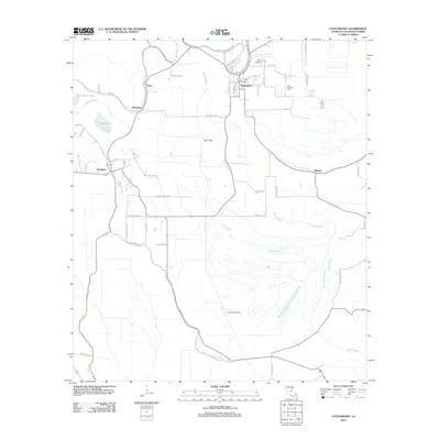
2012 Map of Cottonport
USGS Topo · Published 2012About this map
Cottonport serves as the primary hub in this low-lying landscape of central Louisiana, where a dense network of bayous and canals dictates the pattern of rural settlement. The meandering path of Bayou Rouge defines much of the terrain, flanked by smaller communities like Enterprise and Karo. This survey captures the region's agricultural and industrial character, notably including the Big Cane Gas Field in the southern portion of the quadrangle. Significant water bodies such as Jews-harp Lake and Boogy Lake sit amidst a grid of local roads named for established residents, including Fp Bordelon Rd and Claude Clark Rd. The local infrastructure is further marked by Max Airport and Saint Anthony Cem, providing a detailed look at the community fabric of Avoyelles Parish in the early 21st century.
Find a feature on this map
59 named features on this map. Tap any name to fly to it.
Don’t see what you’re looking for? This feature index may not catch every label — zoom into the map to look around manually.
Map Details
Editions of this 2012 Cottonport Map
This is the sole edition of this map. No revisions or reprints were ever made.
Other maps of this area

1940 · Marksville
USGS Topo · 1:62,500

1941 · Voorhies
USGS Topo · 1:62,500

1948 · Bunkie
USGS Topo · 1:62,500

1952 · Lake Charles
USGS Topo · 1:250,000

1953 · Alexandria
USGS Topo · 1:250,000

1953 · Natchez
USGS Topo · 1:250,000

1954 · Lake Charles
USGS Topo · 1:250,000

1954 · Baton Rouge
USGS Topo · 1:250,000

1955 · Odenburg
USGS Topo · 1:62,500

1955 · Alexandria
USGS Topo · 1:250,000