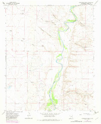
1967 Map of Cottonwood Draw
USGS Topo · Published 1982About this map
The Pecos River carves a winding path through this Chaves County landscape, its riparian corridor standing out against a desert plateau defined by ephemeral drainage networks. During the late 1960s, this area remained largely defined by ranching and resource extraction, with the Benedict Ranch and Cottonwood Ranch anchoring the northern and southern reaches. The infrastructure of the era is marked by numerous Drill Holes and a prominent Pipeline, indicating active exploration and transport through the basin.
Find a feature on this map
31 named features on this map. Tap any name to fly to it.
Don’t see what you’re looking for? This feature index may not catch every label — zoom into the map to look around manually.
Map Details
Editions of this 1967 Cottonwood Draw Map
2 editions found
Other maps of this area

1955 · Roswell
USGS Topo · 1:250,000

1958 · Roswell
USGS Topo · 1:250,000

1962 · Roswell
USGS Topo · 1:250,000

1962 · Eightmile Draw
USGS Topo · 1:24,000

1963 · Coyote Draw
USGS Topo · 1:24,000

1967 · Deering Place
USGS Topo · 1:24,000

1967 · Haystack Mountain
USGS Topo · 1:24,000

1967 · Cottonwood Draw
USGS Topo · 1:24,000

1967 · Swallow Nest Canyon
USGS Topo · 1:24,000

1967 · Hernandez Lake
USGS Topo · 1:24,000