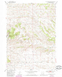
1950 Map of Cottonwood Falls
USGS Topo · Published 1985About this map
Cottonwood Falls marks the center of this Wyoming landscape, where the waters of Cottonwood Creek cut through the terrain of Platte County. The western edge of the map is defined by the boundary of the Medicine Bow National Forest, illustrating the intersection of managed timberlands and the open grazing territory common in this part of the state. These hills are etched with a series of drainage systems including Crow Creek, Dagley Creek, and Sand Draw, which dictate the local topography.
Find a feature on this map
14 named features on this map. Tap any name to fly to it.
Don’t see what you’re looking for? This feature index may not catch every label — zoom into the map to look around manually.
Map Details
Editions of this 1950 Cottonwood Falls Map
2 editions found
Other maps of this area

1943 · Esterbrook
USGS Topo · 1:62,500

1945 · Esterbrook
USGS Topo · 1:62,500

1949 · Spring Creek
USGS Topo · 1:24,000

1950 · Spring Creek
USGS Topo · 1:24,000

1950 · Coleman Butte
USGS Topo · 1:24,000

1950 · Cottonwood Falls
USGS Topo · 1:24,000

1951 · Coleman Butte
USGS Topo · 1:24,000

1951 · Sibley Peak
USGS Topo · 1:24,000

1951 · Cottonwood Falls
USGS Topo · 1:24,000

1953 · Lewis Flat
USGS Topo · 1:24,000