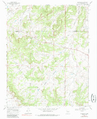
1966 Map of Counselor
USGS Topo · Published 1986About this map
Counselor serves as a focal point in this high-desert landscape, situated along the shared border of Rio Arriba Co and Sandoval Co. The area is characterized by the expansive Snahyel Mesa and a network of deep drainage systems including Escrito Canyon, Gallo Canyon, and Venado Canyon. To the east, the Jicarilla Apache Indian Reservation Boundary marks a significant cultural and jurisdictional transition.
Find a feature on this map
15 named features on this map. Tap any name to fly to it.
Don’t see what you’re looking for? This feature index may not catch every label — zoom into the map to look around manually.
Map Details
Editions of this 1966 Counselor Map
2 editions found
Other maps of this area

1889 · Largo
USGS Topo · 1:250,000

1895 · Largo
USGS Topo · 1:250,000

1954 · Aztec
USGS Topo · 1:250,000

1958 · Aztec
USGS Topo · 1:250,000

1959 · Nageezi
USGS Topo · 1:62,500

1962 · Aztec
USGS Topo · 1:250,000

1963 · Tayfoya Canyon
USGS Topo · 1:24,000

1963 · Otero Store
USGS Topo · 1:24,000

1965 · Aztec
USGS Topo · 1:250,000
1966 · Tancosa Windmill
USGS Topo · 1:24,000
Featured Places
- Eastern Navajo Agency, NM
- Counselor, Eastern Navajo Agency
- Sandoval County, NM
- Rio Arriba County, NM
- United States