
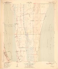
1951 Map of Courtenay
USGS Topo · Published 1951About this map
Merritt Island is depicted here during a period of transition, just before the space-age development that would soon redefine this stretch of the Florida coast. Centered on the northern portion of the island, the landscape is a mosaic of wetlands and tidal waters, with the Banana River and Indian River flanking the central ridge. Small community centers like Courtenay and Indianola are visible, each marked by local landmarks such as St Lukes Ch and the Indianola Cem. Along the western shore, the Florida East Coast rail line parallels the coast through City Point and into the northern edge of Cocoa. The interior of the island is dominated by the marshy expanse of Sykes Creek, showing the natural hydrology of the area before the extensive canal systems of later decades were fully established.
Find a feature on this map
26 named features on this map. Tap any name to fly to it.
Don’t see what you’re looking for? This feature index may not catch every label — zoom into the map to look around manually.
Map Details
Editions of this 1951 Courtenay Map
2 editions found
Other maps of this area

1949 · Orsino
USGS Topo · 1:24,000

1949 · False Cape
USGS Topo · 1:24,000

1949 · Titusville
USGS Topo · 1:24,000

1949 · Courtenay
USGS Topo · 1:24,000

1949 · Sharpes
USGS Topo · 1:24,000

1949 · Cocoa
USGS Topo · 1:24,000

1949 · Cocoa Beach
USGS Topo · 1:24,000

1951 · False Cape
USGS Topo · 1:24,000

1951 · Cocoa
USGS Topo · 1:24,000

1951 · Sharpes
USGS Topo · 1:24,000