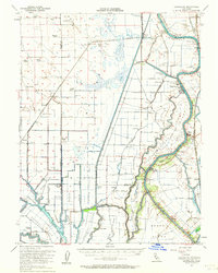
1952 Map of Courtland
USGS Topo · Published 1964About this map
The Sacramento River anchors this mid-century survey of the California Delta, revealing a landscape defined by an intricate network of sloughs, cuts, and fertile islands. Major agricultural and industrial landmarks like the Sugar Beet Plant near Clarksburg and various Gas Wells underscore the region's economic drivers. The map documents numerous family-named properties such as Maxwell Ranch, Glide Ranch, and Bulkley Ranch, which sit alongside established river towns like Courtland and Hood.
Find a feature on this map
104 named features on this map. Tap any name to fly to it.
Don’t see what you’re looking for? This feature index may not catch every label — zoom into the map to look around manually.
Map Details
Editions of this 1952 Courtland Map
3 editions found
Other maps of this area

1891 · Sacramento
USGS Topo · 1:125,000

1892 · Sacramento
USGS Topo · 1:125,000

1893 · Sacramento
USGS Topo · 1:125,000

1894 · Lodi
USGS Topo · 1:125,000

1902 · Fairoaks
USGS Topo · 1:62,500

1907 · Woodland
USGS Topo · 1:62,500

1907 · Davisville
USGS Topo · 1:62,500

1907 · Antioch
USGS Topo · 1:62,500

1908 · Vacaville
USGS Topo · 1:62,500

1908 · Courtland
USGS Topo · 1:62,500