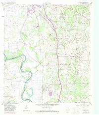
1958 Map of Courtney
USGS Topo · Published 1989About this map
The Brazos River meanders along the boundary of Grimes and Washington Counties, defining the western edge of this landscape at the close of the 1950s. To the south, the community of Courtney sits near the crossing of Beason Creek, serving as a central point for a rural network of churches and cemeteries. Religious life is anchored by St Paul Ch and Mercy Seat Ch, while local history is etched into the grounds of Sand Prairie Cem and Sommerford Cem.
Find a feature on this map
27 named features on this map. Tap any name to fly to it.
Don’t see what you’re looking for? This feature index may not catch every label — zoom into the map to look around manually.
Map Details
Editions of this 1958 Courtney Map
3 editions found
Other maps of this area

1913 · Millican
USGS Topo · 1:31,680

1914 · Navasota
USGS Topo · 1:62,500

1954 · Beaumont
USGS Topo · 1:250,000

1954 · Austin
USGS Topo · 1:250,000

1956 · Hempstead
USGS Topo · 1:62,500

1957 · Beaumont
USGS Topo · 1:250,000

1958 · Washington
USGS Topo · 1:24,000

1958 · Navasota
USGS Topo · 1:24,000

1958 · Courtney
USGS Topo · 1:24,000

1959 · Millican
USGS Topo · 1:24,000