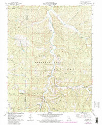
1978 Map of Courtois
USGS Topo · Published 1985About this map
Courtois Creek winds through the heart of the Mark Twain National Forest in this detailed survey of the Missouri Ozarks. The landscape is defined by its complex drainage network, where the Middle Fork Shoal Creek and Hazel Creek carve deep through the surrounding hills. Small rural settlements like Brazil and Quaker anchor the map, while industrial presence is noted by the waste disposal ponds and a claypit. Local social life is mapped through several country churches, including Sugar Grove Ch and Joseph Chapel. Topographic features like Murry Hill and various hollows such as Boiling Springs Hollow illustrate the difficult terrain that likely shaped the region's development. For genealogists, the map identifies specific burial sites like Linkerson Cem and Antioch Cem, offering precise locations for family history research.
Find a feature on this map
40 named features on this map. Tap any name to fly to it.
Don’t see what you’re looking for? This feature index may not catch every label — zoom into the map to look around manually.
Map Details
Editions of this 1978 Courtois Map
3 editions found

Other maps of this area

1906 · Potosi
USGS Topo · 1:62,500

1924 · Edgehill
USGS Topo · 1:62,500

1926 · Edgehill
USGS Topo · 1:62,500

1943 · Berryman
USGS Topo · 1:62,500

1943 · Boss
USGS Topo · 1:62,500

1945 · Berryman
USGS Topo · 1:62,500

1946 · Boss
USGS Topo · 1:62,500

1949 · Rolla
USGS Topo · 1:250,000

1953 · Rolla
USGS Topo · 1:250,000

1954 · Rolla
USGS Topo · 1:250,000