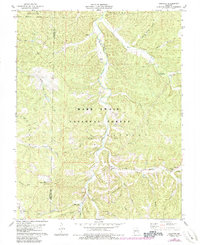
1978 Map of Courtois
USGS Topo · Published 1985About this map
Courtois and Brazil serve as the primary focal points of this 1970s landscape, situated within the expansive Mark Twain National Forest. The map documents a rural Ozark terrain defined by the winding course of Courtois Creek and its many tributaries, including Boiling Springs Hollow and Hazel Creek. The drainage patterns suggest a deeply dissected plateau, where local life centered around small country congregations and family burial grounds. Researchers can identify numerous spiritual and social landmarks such as Sugar Grove Ch, Bethel Ch, and Joseph Chapel, alongside the Antioch Cem and Jinkerson Cem. This era shows a mix of traditional land use and conservation, with the Czar Lookout Tower standing over the forest while newer facilities like the Hazel Creek Campground and Waste Disposal Ponds indicate evolving management of the region's natural resources.
Find a feature on this map
40 named features on this map. Tap any name to fly to it.
Don’t see what you’re looking for? This feature index may not catch every label — zoom into the map to look around manually.
Map Details
Editions of this 1978 Courtois Map
3 editions found

Other maps of this area

1906 · Potosi
USGS Topo · 1:62,500

1924 · Edgehill
USGS Topo · 1:62,500

1926 · Edgehill
USGS Topo · 1:62,500

1943 · Berryman
USGS Topo · 1:62,500

1943 · Boss
USGS Topo · 1:62,500

1945 · Berryman
USGS Topo · 1:62,500

1946 · Boss
USGS Topo · 1:62,500

1949 · Rolla
USGS Topo · 1:250,000

1953 · Rolla
USGS Topo · 1:250,000

1954 · Rolla
USGS Topo · 1:250,000