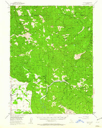
1952 Map of Covelo
USGS Topo · Published 1960About this map
Covelo and its surrounding agricultural valley serve as the focal point of this Mendocino County survey, where the township grid meets the complex topography of the Mendocino National Forest. The landscape is defined by the Middle Fork Eel River and its numerous tributaries like Williams Creek and Mill Creek, which drain the steep ridges of the California Coast Ranges. Evidence of early settlement and land use is found in the distribution of family holdings such as Bauer Ranch, Spencer Ranch, and Capistran Ranch, alongside civic landmarks like the Reservation School within the Indian Reservation.
Find a feature on this map
90 named features on this map. Tap any name to fly to it.
Don’t see what you’re looking for? This feature index may not catch every label — zoom into the map to look around manually.
Map Details
Editions of this 1952 Covelo Map
4 editions found

Other maps of this area

1890 · Red Bluff
USGS Topo · 1:250,000

1894 · Red Bluff
USGS Topo · 1:250,000

1920 · Covelo
USGS Topo · 1:62,500

1921 · Hoaglin
USGS Topo · 1:62,500

1922 · Island Mountain
USGS Topo · 1:62,500

1926 · Covelo
USGS Topo · 1:62,500

1929 · Eden Valley
USGS Topo · 1:62,500

1931 · Hoaglin
USGS Topo · 1:96,000

1935 · Hoaglin
USGS Topo · 1:125,000

1951 · Laytonville
USGS Topo · 1:62,500