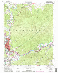
1962 Map of Covington
USGS Topo · Published 1984About this map
The city of Covington serves as a hub of industry and transport in this 1960s survey, updated with purple revisions from the early 1980s. Following the bends of the Jackson River, the Chesapeake and Ohio railroad corridor anchors the local economy, connecting residential neighborhoods like Rayon Terrace, Edgemont, and Mallow to the central business district. The landscape transitions sharply from the urbanized valley floor to the protected ridges of the George Washington National Forest, where topography like Warm Springs Mountain and Peters Ridge dominates. Evidence of the region’s extractive history is visible in the Rich Patch Mines and various quarries scattered through the hills. Local social centers are well-documented, ranging from the Alleghany Country Club to multiple schools such as Watson High Sch and Central High Sch.
Find a feature on this map
62 named features on this map. Tap any name to fly to it.
Don’t see what you’re looking for? This feature index may not catch every label — zoom into the map to look around manually.
Map Details
Editions of this 1962 Covington Map
4 editions found
Other maps of this area

1887 · Lewisburg
USGS Topo · 1:125,000

1891 · Lewisburg
USGS Topo · 1:125,000

1894 · Natural Bridge
USGS Topo · 1:125,000

1913 · Eagle Rock
USGS Topo · 1:48,000

1915 · Eagle Rock
USGS Topo · 1:62,500

1921 · Callaghan
USGS Topo · 1:48,000

1923 · Callaghan
USGS Topo · 1:62,500

1929 · Falling Spring
USGS Topo · 1:24,000

1931 · Healing Springs
USGS Topo · 1:24,000

1932 · Falling Spring
USGS Topo · 1:31,680