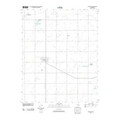
2009 Map of Covington
USGS Topo · Published 2009About this map
Covington serves as the primary hub in this Garfield County landscape, appearing as a compact grid of streets amid a broader agricultural and hydrological network. The surrounding terrain is defined by an extensive system of flood control and water management, featuring numerous named sites such as the Upper Black Bear Creek Site 40 Reservoir and the Upper Black Bear Creek Site 42 Reservoir. These engineered structures coordinate with the natural drainage of Black Bear Creek and Panther Creek, illustrating the area's twentieth-century transition toward managed water resources for local farming and conservation.
Find a feature on this map
28 named features on this map. Tap any name to fly to it.
Don’t see what you’re looking for? This feature index may not catch every label — zoom into the map to look around manually.
Map Details
Editions of this 2009 Covington Map
This is the sole edition of this map. No revisions or reprints were ever made.
Other maps of this area

1893 · Mulhall
USGS Topo · 1:62,500

1893 · Lovell
USGS Topo · 1:62,500

1955 · Enid
USGS Topo · 1:250,000

1956 · Garber
USGS Topo · 1:62,500

1958 · Enid
USGS Topo · 1:250,000

1972 · Perry NW
USGS Topo · 1:24,000

1972 · Lucien
USGS Topo · 1:24,000

1974 · Marshall West
USGS Topo · 1:24,000

1974 · Marshall East
USGS Topo · 1:24,000
1974 · Orlando West
USGS Topo · 1:24,000