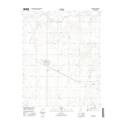
2016 Map of Covington
USGS Topo · Published 2016About this map
Covington serves as the primary hub in this rural Garfield County landscape, where a grid of section-line roads like Southgate Rd and Skeleton Rd defines the agricultural character of north-central Oklahoma. The town's local history is anchored by the Covington Community Cem and a compact residential core including Washington St and Monroe St. Beyond the main settlement, smaller communities such as Hayward and Callahan are linked by State Highway 164. The geography is marked by an extensive watershed management system, featuring numerous reservoirs and sites along Black Bear Cr and its tributaries, including Panther Cr and Four-D Cr. These man-made water bodies, such as Hayward Lake and the Upper Black Bear Cr Site 42 Reservoir, provide a localized view of how water control has shaped the prairie terrain for farming and ranching.
Find a feature on this map
44 named features on this map. Tap any name to fly to it.
Don’t see what you’re looking for? This feature index may not catch every label — zoom into the map to look around manually.
Map Details
Editions of this 2016 Covington Map
This is the sole edition of this map. No revisions or reprints were ever made.
Other maps of this area

1893 · Mulhall
USGS Topo · 1:62,500

1893 · Lovell
USGS Topo · 1:62,500

1955 · Enid
USGS Topo · 1:250,000

1956 · Garber
USGS Topo · 1:62,500

1958 · Enid
USGS Topo · 1:250,000

1972 · Perry NW
USGS Topo · 1:24,000

1972 · Lucien
USGS Topo · 1:24,000

1974 · Marshall West
USGS Topo · 1:24,000

1974 · Marshall East
USGS Topo · 1:24,000
1974 · Orlando West
USGS Topo · 1:24,000