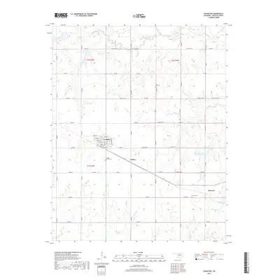
2018 Map of Covington
USGS Topo · Published 2018About this map
Covington serves as the primary hub in this portion of Garfield County, defined by a grid of streets including Washington St and Jackson St. The surrounding landscape is dominated by agricultural sections and a network of creeks like Black Bear Cr and Crow Cr that wind through the prairie terrain. To the southeast, the small settlement of Hayward sits near its namesake Hayward Lake and Hayward Cem. The map reveals the critical role of water management in the region, most notably at the Upper Black Bear Cr Site 42 Reservoir. Genealogists will find interest in the scattered burial grounds that serve local communities, such as Saint John Cem and the Covington Community Cem. The transportation network is a mix of established section-line roads like Wheat Capitol Rd and newer routes that facilitate the movement of goods through this rural landscape.
Find a feature on this map
48 named features on this map. Tap any name to fly to it.
Don’t see what you’re looking for? This feature index may not catch every label — zoom into the map to look around manually.
Map Details
Editions of this 2018 Covington Map
This is the sole edition of this map. No revisions or reprints were ever made.
Other maps of this area

1893 · Mulhall
USGS Topo · 1:62,500

1893 · Lovell
USGS Topo · 1:62,500

1955 · Enid
USGS Topo · 1:250,000

1956 · Garber
USGS Topo · 1:62,500

1958 · Enid
USGS Topo · 1:250,000

1972 · Perry NW
USGS Topo · 1:24,000

1972 · Lucien
USGS Topo · 1:24,000

1974 · Marshall West
USGS Topo · 1:24,000

1974 · Marshall East
USGS Topo · 1:24,000
1974 · Orlando West
USGS Topo · 1:24,000