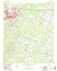
1964 Map of Covington
USGS Topo · Published 1986About this map
Covington and the neighboring academic community of Oxford serve as the primary anchors of this mid-century Georgia landscape. The map illustrates a period of industrial and infrastructure transition, with the Seaboard Coast Line and Georgia railroads intersecting near the city's commercial core, while the newer paths of Interchange 46 and Interchange 47 signal the coming highway era. Beyond the urban limits, the terrain is defined by the winding course of the Alcovy River and its numerous tributaries, including Dried Indian Creek and Cornish Creek.
Find a feature on this map
61 named features on this map. Tap any name to fly to it.
Don’t see what you’re looking for? This feature index may not catch every label — zoom into the map to look around manually.
Map Details
Editions of this 1964 Covington Map
3 editions found
Other maps of this area

1896 · Monroe
USGS Topo · 1:125,000

1953 · Athens
USGS Topo · 1:250,000

1958 · Athens
USGS Topo · 1:250,000

1959 · Athens
USGS Topo · 1:250,000

1963 · Athens
USGS Topo · 1:250,000

1964 · Stewart
USGS Topo · 1:24,000

1964 · Worthville
USGS Topo · 1:24,000

1964 · Porterdale
USGS Topo · 1:24,000

1964 · Covington
USGS Topo · 1:24,000
1964 · Milstead
USGS Topo · 1:24,000