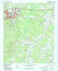
1964 Map of Covington
USGS Topo · Published 1986About this map
Covington serves as the focal point of this mid-century survey, showing the city's development alongside the educational presence of Emory Jr College. The landscape is defined by the convergence of the Alcovy River and numerous tributaries like Dried Indian Creek and Cornish Creek. Transportation is anchored by the Seaboard Coast Line and the Central of Georgia railroads, which linked these rural communities to the wider region.
Find a feature on this map
71 named features on this map. Tap any name to fly to it.
Don’t see what you’re looking for? This feature index may not catch every label — zoom into the map to look around manually.
Map Details
Editions of this 1964 Covington Map
3 editions found
Other maps of this area

1896 · Monroe
USGS Topo · 1:125,000

1953 · Athens
USGS Topo · 1:250,000

1958 · Athens
USGS Topo · 1:250,000

1959 · Athens
USGS Topo · 1:250,000

1963 · Athens
USGS Topo · 1:250,000

1964 · Stewart
USGS Topo · 1:24,000

1964 · Worthville
USGS Topo · 1:24,000

1964 · Porterdale
USGS Topo · 1:24,000

1964 · Covington
USGS Topo · 1:24,000
1964 · Milstead
USGS Topo · 1:24,000