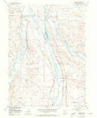
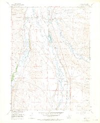
1956 Map of Cowdrey
USGS Topo · Published 1973About this map
The Union Pacific railroad line defines the central corridor of this Jackson County landscape, passing through the settlement of Cowdrey as it parallels the Michigan River. This 1956 survey documents an era of intensive water management in a high-elevation ranching environment, evidenced by an intricate network of irrigation channels including the Poquette Ditch, Davis Ditch, and the curiously named Give A Dam Ditch. These systems divert water from the North Platte River and its tributaries to support family operations like the Hanson Ranch, Carlstrom Ranch, and Hill Ranch. To the southeast, the emergence of the local petroleum industry is visible near the Oil Field and Walden-Jackson County Airport. The map also captures the confluence of the Canadian River and the Michigan, illustrating how the natural hydrology was adapted for 20th-century agriculture and energy extraction.
Find a feature on this map
51 named features on this map. Tap any name to fly to it.
Don’t see what you’re looking for? This feature index may not catch every label — zoom into the map to look around manually.
Map Details
Editions of this 1956 Cowdrey Map
5 editions found
Other maps of this area

1950 · Northgate
USGS Topo · 1:24,000

1950 · Kings Canyon
USGS Topo · 1:24,000

1952 · Northgate
USGS Topo · 1:24,000

1952 · Kings Canyon
USGS Topo · 1:24,000

1954 · Craig
USGS Topo · 1:250,000

1955 · Independence Mountain
USGS Topo · 1:24,000

1955 · Lake John
USGS Topo · 1:24,000

1955 · Eagle Hill
USGS Topo · 1:24,000

1955 · Delaney Butte
USGS Topo · 1:24,000

1955 · Gould NW
USGS Topo · 1:24,000