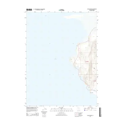
2014 Map of Coyote Point
USGS Topo · Published 2014About this map
Great Salt Lake dominates the western half of this 2014 topographic study, where the vast water body meets the arid eastern shore of Box Elder County. The landscape is defined by dramatic elevation changes along the coast, rising from the shoreline to the heights of Black Mtn. At the southern edge of the peninsula, Coyote Point serves as a prominent landmark overlooking Coyote Ponds, a small collection of water bodies at the lake's fringe. The map illustrates a stark divide between the open waters of Spring Bay and the complex contouring of the inland terrain, offering a clear record of the shoreline and public land survey boundaries in the early 21st century.
Find a feature on this map
7 named features on this map. Tap any name to fly to it.
Don’t see what you’re looking for? This feature index may not catch every label — zoom into the map to look around manually.
Map Details
Editions of this 2014 Coyote Point Map
This is the sole edition of this map. No revisions or reprints were ever made.
Other maps of this area

1954 · Brigham City
USGS Topo · 1:250,000

1958 · Brigham City
USGS Topo · 1:250,000

1962 · Brigham City
USGS Topo · 1:250,000

1968 · Rozel
USGS Topo · 1:24,000

1968 · Lake Ridge
USGS Topo · 1:24,000

1968 · Monument Point
USGS Topo · 1:24,000

1968 · Coyote Point
USGS Topo · 1:24,000

1968 · Rozel Point
USGS Topo · 1:24,000

1969 · Spring Bay SW
USGS Topo · 1:24,000
1969 · Gunnison Island NE
USGS Topo · 1:24,000