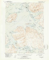
1951 Map of Craig B-4
USGS Topo · Published 1953About this map
Craig serves as a primary coastal anchor on the western edge of Prince of Wales Island in the early 1950s, overlooking a complex network of inlets and islands. This coastal survey captures a distinct maritime economy, featuring the Waterfall Cannery and its supporting Aqueduct infrastructure to the south. Near the established settlement of Craig, the map identifies an Indian Village (Aban'd) on Fish Egg Island, providing a specific record of shifting indigenous settlement patterns in the Klawak Inlet area. The geography is defined by significant landmasses like San Fernando Island and San Juan Bautista Island, separated by the deep waters of Bucareli Bay and Ursua Channel. Inland, the terrain rises sharply to heights such as Sunny Hay Mountain and Bautista Peak, while the coastline is dotted with numerous small harbors including Port San Antonio and Port Estrella.
Find a feature on this map
77 named features on this map. Tap any name to fly to it.
Don’t see what you’re looking for? This feature index may not catch every label — zoom into the map to look around manually.
Map Details
Editions of this 1951 Craig B-4 Map
3 editions found
Other maps of this area

1948 · Craig A-4
USGS Topo · 1:63,360

1948 · Craig B-5
USGS Topo · 1:63,360

1948 · Craig A-5
USGS Topo · 1:63,360

1948 · Craig A-3
USGS Topo · 1:63,360

1949 · Craig B-3
USGS Topo · 1:63,360

1949 · Craig C-3
USGS Topo · 1:63,360

1949 · Craig C-4
USGS Topo · 1:63,360

1949 · Craig B-4
USGS Topo · 1:63,360

1951 · Craig C-3
USGS Topo · 1:63,360

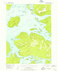
1951 · Craig B-4
USGS Topo · 1:63,360