1950 Map of Craig C-1
USGS Topo · Published 1982About this map
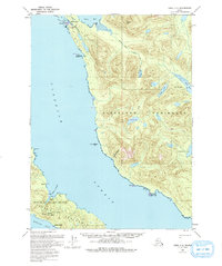
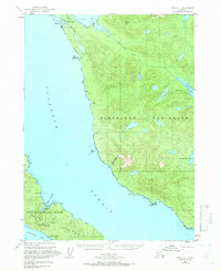
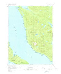
Clarence Strait separates the rugged shoreline of the Cleveland Peninsula from Prince Of Wales Island in this 1950 coastal survey. The map reveals the intricate maritime and mining economy of mid-century Southeast Alaska, centered around the settlement at Meyers Chuck and the industrial activity near Hadley and Boggs Landing. On the Cleveland Peninsula, the interior is dotted with remote alpine waters like Rainbow Lake and Smugglers Lake, while the eastern flank near Helm Bay shows signs of mineral exploration at the Sleeping Beauty Mine and Bert Lide Mine. Further south, the Kaasan Peninsula is marked by the Mamie Mine and the peak of Mt Andrew, highlighting the era's focus on the region's copper and gold potential. This survey captures a moment when coastal settlements were essential hubs for the surrounding wilderness and maritime trades.
Find a feature on this map
35 named features on this map. Tap any name to fly to it.
Don’t see what you’re looking for? This feature index may not catch every label — zoom into the map to look around manually.
Map Details
Editions of this 1950 Craig C-1 Map
4 editions found
Historical Maps of Meyers Chuck Through Time
659 maps found

1948 Craig A-1
Prince of Wales-Hyder Borough, AK

1948 Craig A-2
Prince of Wales-Hyder Borough, AK

1948 Craig A-3
Prince of Wales-Hyder Borough, AK

1948 Craig A-4
Prince of Wales-Hyder Borough, AK

1948 Craig A-5
Prince of Wales-Hyder Borough, AK

1948 Craig B-5
Prince of Wales-Hyder Borough, AK

1948 Craig B-6
Prince of Wales-Hyder Borough, AK

1948 Dixon Entrance C-1
Prince of Wales-Hyder Borough, AK

1948 Dixon Entrance C-3
Prince of Wales-Hyder Borough, AK

1948 Dixon Entrance D-1
Prince of Wales-Hyder Borough, AK

1948 Dixon Entrance D-2
Prince of Wales-Hyder Borough, AK

1948 Dixon Entrance D-3
Prince of Wales-Hyder Borough, AK

1948 Dixon Entrance D-4
Prince of Wales-Hyder Borough, AK

1948 Dixon Entrance D-5
Prince of Wales-Hyder Borough, AK

1948 Ketchikan A-6
Prince of Wales-Hyder Borough, AK

1948 Petersburg A-2
Prince of Wales-Hyder Borough, AK

1948 Petersburg A-6
Prince of Wales-Hyder Borough, AK

1948 Petersburg B-3
Prince of Wales-Hyder Borough, AK

1948 Petersburg B-6
Prince of Wales-Hyder Borough, AK

1948 Prince Rupert D-6
Prince of Wales-Hyder Borough, AK

1949 Craig B-1
Prince of Wales-Hyder Borough, AK

1949 Craig B-2
Prince of Wales-Hyder Borough, AK

1949 Craig B-3
Prince of Wales-Hyder Borough, AK

1949 Craig B-4
Prince of Wales-Hyder Borough, AK

1949 Craig C-2
Prince of Wales-Hyder Borough, AK

1949 Craig C-3
Prince of Wales-Hyder Borough, AK

1949 Craig C-4
Prince of Wales-Hyder Borough, AK

1949 Craig D-1
Prince of Wales-Hyder Borough, AK

1949 Craig D-2
Prince of Wales-Hyder Borough, AK

1949 Craig D-3
Prince of Wales-Hyder Borough, AK

1949 Craig D-4
Prince of Wales-Hyder Borough, AK

1949 Ketchikan C-6
Prince of Wales-Hyder Borough, AK

1949 Petersburg A-3
Prince of Wales-Hyder Borough, AK

1949 Petersburg A-4
Prince of Wales-Hyder Borough, AK

1949 Petersburg A-5
Prince of Wales-Hyder Borough, AK

1949 Petersburg B-4
Prince of Wales-Hyder Borough, AK

1949 Petersburg B-5
Prince of Wales-Hyder Borough, AK

1950 Craig B-1
Prince of Wales-Hyder Borough, AK

1950 Craig C-1
Prince of Wales-Hyder Borough, AK

1950 Craig D-3
Prince of Wales-Hyder Borough, AK

1951 Bradfield Canal
Prince of Wales-Hyder Borough, AK

1951 Craig A-2
Prince of Wales-Hyder Borough, AK

1951 Craig A-3
Prince of Wales-Hyder Borough, AK

1951 Craig A-4
Prince of Wales-Hyder Borough, AK

1951 Craig B-2
Prince of Wales-Hyder Borough, AK

1951 Craig B-3
Prince of Wales-Hyder Borough, AK

1951 Craig B-4
Prince of Wales-Hyder Borough, AK

1951 Craig C-1
Prince of Wales-Hyder Borough, AK

1951 Craig C-2
Prince of Wales-Hyder Borough, AK

1951 Craig C-3
Prince of Wales-Hyder Borough, AK

1951 Craig C-4
Prince of Wales-Hyder Borough, AK

1951 Craig C-5
Prince of Wales-Hyder Borough, AK

1951 Craig C-6
Prince of Wales-Hyder Borough, AK

1951 Craig D-1
Prince of Wales-Hyder Borough, AK

1951 Craig D-2
Prince of Wales-Hyder Borough, AK

1951 Craig D-4
Prince of Wales-Hyder Borough, AK

1951 Craig D-5
Prince of Wales-Hyder Borough, AK

1951 Craig D-6
Prince of Wales-Hyder Borough, AK

1951 Dixon Entrance D-2
Prince of Wales-Hyder Borough, AK

1951 Dixon Entrance D-3
Prince of Wales-Hyder Borough, AK

1951 Dixon Entrance D-4
Prince of Wales-Hyder Borough, AK

1951 Dixon Entrance
Prince of Wales-Hyder Borough, AK

1951 Petersburg A-6
Prince of Wales-Hyder Borough, AK

1951 Petersburg B-3
Prince of Wales-Hyder Borough, AK

1951 Petersburg B-4
Prince of Wales-Hyder Borough, AK

1951 Petersburg B-6
Prince of Wales-Hyder Borough, AK

1951 Prince Rupert D-6
Prince of Wales-Hyder Borough, AK

1951 Prince Rupert
Prince of Wales-Hyder Borough, AK

1952 Ketchikan C-6
Prince of Wales-Hyder Borough, AK

1952 Ketchikan D-6
Prince of Wales-Hyder Borough, AK

1952 Petersburg
Prince of Wales-Hyder Borough, AK

1953 Ketchikan D-6
Prince of Wales-Hyder Borough, AK

1953 Petersburg A-2
Prince of Wales-Hyder Borough, AK

1953 Petersburg A-3
Prince of Wales-Hyder Borough, AK

1953 Petersburg A-4
Prince of Wales-Hyder Borough, AK

1953 Petersburg A-5
Prince of Wales-Hyder Borough, AK

1953 Petersburg B-5
Prince of Wales-Hyder Borough, AK

1954 Bradfield Canal
Prince of Wales-Hyder Borough, AK

1955 Bradfield Canal A-1
Prince of Wales-Hyder Borough, AK

1955 Bradfield canal A-2
Prince of Wales-Hyder Borough, AK

1955 Bradfield canal A-3
Prince of Wales-Hyder Borough, AK

1955 Bradfield canal A-4
Prince of Wales-Hyder Borough, AK

1955 Bradfield Canal A-5
Prince of Wales-Hyder Borough, AK

1955 Bradfield canal A-6
Prince of Wales-Hyder Borough, AK

1955 Bradfield canal B-2
Prince of Wales-Hyder Borough, AK

1955 Bradfield canal B-3
Prince of Wales-Hyder Borough, AK

1955 Bradfield canal B-4
Prince of Wales-Hyder Borough, AK

1955 Bradfield Canal
Prince of Wales-Hyder Borough, AK

1955 Ketchikan A-1
Prince of Wales-Hyder Borough, AK

1955 Ketchikan A-2
Prince of Wales-Hyder Borough, AK

1955 Ketchikan A-3
Prince of Wales-Hyder Borough, AK

1955 Ketchikan A-4
Prince of Wales-Hyder Borough, AK

1955 Ketchikan A-5
Prince of Wales-Hyder Borough, AK

1955 Ketchikan B-1
Prince of Wales-Hyder Borough, AK

1955 Ketchikan B-2
Prince of Wales-Hyder Borough, AK

1955 Ketchikan B-3
Prince of Wales-Hyder Borough, AK

1955 Ketchikan C-1
Prince of Wales-Hyder Borough, AK

1955 Ketchikan C-2
Prince of Wales-Hyder Borough, AK

1955 Ketchikan C-3
Prince of Wales-Hyder Borough, AK

1955 Ketchikan D-1
Prince of Wales-Hyder Borough, AK

1955 Ketchikan D-2
Prince of Wales-Hyder Borough, AK

1955 Ketchikan D-3
Prince of Wales-Hyder Borough, AK

1955 Prince Rupert D-1
Prince of Wales-Hyder Borough, AK

1955 Prince Rupert D-2
Prince of Wales-Hyder Borough, AK

1955 Prince Rupert D-3
Prince of Wales-Hyder Borough, AK

1955 Prince Rupert D-4
Prince of Wales-Hyder Borough, AK

1955 Prince Rupert D-5
Prince of Wales-Hyder Borough, AK

1958 Prince Rupert C-2 and C-3
Prince of Wales-Hyder Borough, AK

1959 Dixon Entrance
Prince of Wales-Hyder Borough, AK

1959 Prince Rupert
Prince of Wales-Hyder Borough, AK

1960 Petersburg
Prince of Wales-Hyder Borough, AK

1964 Prince Rupert
Prince of Wales-Hyder Borough, AK

1973 Bradfield Canal B-2
Prince of Wales-Hyder Borough, AK

1994 Craig A-4
Prince of Wales-Hyder Borough, AK

1994 Craig C-2
Prince of Wales-Hyder Borough, AK

1994 Craig C-3
Prince of Wales-Hyder Borough, AK

1994 Craig D-2
Prince of Wales-Hyder Borough, AK

1994 Craig D-3
Prince of Wales-Hyder Borough, AK

1994 Craig D-4
Prince of Wales-Hyder Borough, AK

1994 Dixon Entrance C-3
Prince of Wales-Hyder Borough, AK

1994 Dixon Entrance D-1
Prince of Wales-Hyder Borough, AK

1994 Petersburg A-3
Prince of Wales-Hyder Borough, AK

1994 Petersburg A-4
Prince of Wales-Hyder Borough, AK

1995 Bradfield Canal A-4
Prince of Wales-Hyder Borough, AK

1995 Ketchikan C-6
Prince of Wales-Hyder Borough, AK

1995 Petersburg A-2
Prince of Wales-Hyder Borough, AK

1995 Petersburg A-5
Prince of Wales-Hyder Borough, AK

1995 Petersburg B-3
Prince of Wales-Hyder Borough, AK

1995 Petersburg B-4
Prince of Wales-Hyder Borough, AK

1995 Petersburg B-5
Prince of Wales-Hyder Borough, AK

1996 Bradfield Canal A-1
Prince of Wales-Hyder Borough, AK

1996 Craig A-2
Prince of Wales-Hyder Borough, AK

1996 Craig D-5
Prince of Wales-Hyder Borough, AK

1996 Ketchikan C-2
Prince of Wales-Hyder Borough, AK

1996 Ketchikan C-3
Prince of Wales-Hyder Borough, AK

1996 Ketchikan D-2
Prince of Wales-Hyder Borough, AK

1996 Ketchikan D-3
Prince of Wales-Hyder Borough, AK

1997 Bradfield Canal A-1
Prince of Wales-Hyder Borough, AK

1997 Craig A-1
Prince of Wales-Hyder Borough, AK

1997 Craig A-3
Prince of Wales-Hyder Borough, AK

1997 Craig B-2
Prince of Wales-Hyder Borough, AK

2000 Bradfield Canal A-1
Prince of Wales-Hyder Borough, AK

2000 Bradfield Canal A-2
Prince of Wales-Hyder Borough, AK

2000 Bradfield Canal A-6
Prince of Wales-Hyder Borough, AK

2000 Craig B-5
Prince of Wales-Hyder Borough, AK

2000 Craig B-6
Prince of Wales-Hyder Borough, AK

2000 Craig D-1
Prince of Wales-Hyder Borough, AK

2000 Ketchikan D-6
Prince of Wales-Hyder Borough, AK

2017 Bradfield Canal A-4 NE
Prince of Wales-Hyder Borough, AK

2017 Bradfield Canal A-4 NW
Prince of Wales-Hyder Borough, AK

2017 Bradfield Canal A-4 SE
Prince of Wales-Hyder Borough, AK

2017 Bradfield Canal A-4 SW
Prince of Wales-Hyder Borough, AK

2017 Bradfield Canal A-5 NE
Prince of Wales-Hyder Borough, AK

2017 Bradfield Canal A-5 SE
Prince of Wales-Hyder Borough, AK

2017 Bradfield Canal A-5 SW
Prince of Wales-Hyder Borough, AK

2017 Bradfield Canal A-6 SE
Prince of Wales-Hyder Borough, AK

2017 Bradfield Canal A-6 SW
Prince of Wales-Hyder Borough, AK

2017 Bradfield Canal B-4 NE
Prince of Wales-Hyder Borough, AK

2017 Bradfield Canal B-4 SE
Prince of Wales-Hyder Borough, AK

2017 Craig A-1 NE
Prince of Wales-Hyder Borough, AK

2017 Craig A-1 NW
Prince of Wales-Hyder Borough, AK

2017 Craig A-1 SE
Prince of Wales-Hyder Borough, AK

2017 Craig A-1 SW
Prince of Wales-Hyder Borough, AK

2017 Craig A-2 NE
Prince of Wales-Hyder Borough, AK

2017 Craig A-2 NW
Prince of Wales-Hyder Borough, AK

2017 Craig A-2 SE
Prince of Wales-Hyder Borough, AK

2017 Craig A-2 SW
Prince of Wales-Hyder Borough, AK

2017 Craig A-3 NE
Prince of Wales-Hyder Borough, AK

2017 Craig A-3 NW
Prince of Wales-Hyder Borough, AK

2017 Craig A-3 SE
Prince of Wales-Hyder Borough, AK

2017 Craig A-3 SW
Prince of Wales-Hyder Borough, AK

2017 Craig A-4 NE
Prince of Wales-Hyder Borough, AK

2017 Craig A-4 NW
Prince of Wales-Hyder Borough, AK

2017 Craig A-4 SE
Prince of Wales-Hyder Borough, AK

2017 Craig A-4 SW
Prince of Wales-Hyder Borough, AK

2017 Craig A-5 NE
Prince of Wales-Hyder Borough, AK

2017 Craig A-5 NW
Prince of Wales-Hyder Borough, AK

2017 Craig B-1 NE
Prince of Wales-Hyder Borough, AK

2017 Craig B-1 NW
Prince of Wales-Hyder Borough, AK

2017 Craig B-1 SE
Prince of Wales-Hyder Borough, AK

2017 Craig B-1 SW
Prince of Wales-Hyder Borough, AK

2017 Craig B-2 NE
Prince of Wales-Hyder Borough, AK

2017 Craig B-2 NW
Prince of Wales-Hyder Borough, AK

2017 Craig B-2 SE
Prince of Wales-Hyder Borough, AK

2017 Craig B-2 SW
Prince of Wales-Hyder Borough, AK

2017 Craig B-3 NE
Prince of Wales-Hyder Borough, AK

2017 Craig B-3 NW
Prince of Wales-Hyder Borough, AK

2017 Craig B-3 SE
Prince of Wales-Hyder Borough, AK

2017 Craig B-3 SW
Prince of Wales-Hyder Borough, AK

2017 Craig B-4 NE
Prince of Wales-Hyder Borough, AK

2017 Craig B-4 NW
Prince of Wales-Hyder Borough, AK

2017 Craig B-4 SE
Prince of Wales-Hyder Borough, AK

2017 Craig B-4 SW
Prince of Wales-Hyder Borough, AK

2017 Craig B-5 NE
Prince of Wales-Hyder Borough, AK

2017 Craig B-5 NW
Prince of Wales-Hyder Borough, AK

2017 Craig B-5 SE
Prince of Wales-Hyder Borough, AK

2017 Craig B-5 SW
Prince of Wales-Hyder Borough, AK

2017 Craig B-6 NE
Prince of Wales-Hyder Borough, AK

2017 Craig B-6 SE
Prince of Wales-Hyder Borough, AK

2017 Craig C-1 NE
Prince of Wales-Hyder Borough, AK

2017 Craig C-1 NW
Prince of Wales-Hyder Borough, AK

2017 Craig C-1 SE
Prince of Wales-Hyder Borough, AK

2017 Craig C-1 SW
Prince of Wales-Hyder Borough, AK

2017 Craig C-2 NE
Prince of Wales-Hyder Borough, AK

2017 Craig C-2 NW
Prince of Wales-Hyder Borough, AK

2017 Craig C-2 SE
Prince of Wales-Hyder Borough, AK

2017 Craig C-2 SW
Prince of Wales-Hyder Borough, AK

2017 Craig C-3 NE
Prince of Wales-Hyder Borough, AK

2017 Craig C-3 NW
Prince of Wales-Hyder Borough, AK

2017 Craig C-3 SE
Prince of Wales-Hyder Borough, AK

2017 Craig C-3 SW
Prince of Wales-Hyder Borough, AK

2017 Craig C-4 NE
Prince of Wales-Hyder Borough, AK

2017 Craig C-4 NW
Prince of Wales-Hyder Borough, AK

2017 Craig C-4 SE
Prince of Wales-Hyder Borough, AK

2017 Craig C-4 SW
Prince of Wales-Hyder Borough, AK

2017 Craig C-5 NE
Prince of Wales-Hyder Borough, AK

2017 Craig C-5 NW
Prince of Wales-Hyder Borough, AK

2017 Craig C-5 SE
Prince of Wales-Hyder Borough, AK

2017 Craig C-5 SW
Prince of Wales-Hyder Borough, AK

2017 Craig C-6 SE
Prince of Wales-Hyder Borough, AK

2017 Craig D-1 NE
Prince of Wales-Hyder Borough, AK

2017 Craig D-1 NW
Prince of Wales-Hyder Borough, AK

2017 Craig D-1 SE
Prince of Wales-Hyder Borough, AK

2017 Craig D-1 SW
Prince of Wales-Hyder Borough, AK

2017 Craig D-2 NE
Prince of Wales-Hyder Borough, AK

2017 Craig D-2 NW
Prince of Wales-Hyder Borough, AK

2017 Craig D-2 SE
Prince of Wales-Hyder Borough, AK

2017 Craig D-2 SW
Prince of Wales-Hyder Borough, AK

2017 Craig D-3 NE
Prince of Wales-Hyder Borough, AK

2017 Craig D-3 NW
Prince of Wales-Hyder Borough, AK

2017 Craig D-3 SE
Prince of Wales-Hyder Borough, AK

2017 Craig D-3 SW
Prince of Wales-Hyder Borough, AK

2017 Craig D-4 NE
Prince of Wales-Hyder Borough, AK

2017 Craig D-4 NW
Prince of Wales-Hyder Borough, AK

2017 Craig D-4 SE
Prince of Wales-Hyder Borough, AK

2017 Craig D-4 SW
Prince of Wales-Hyder Borough, AK

2017 Craig D-5 NE
Prince of Wales-Hyder Borough, AK

2017 Craig D-5 NW
Prince of Wales-Hyder Borough, AK

2017 Craig D-5 SE
Prince of Wales-Hyder Borough, AK

2017 Craig D-5 SW
Prince of Wales-Hyder Borough, AK

2017 Craig D-6 NE
Prince of Wales-Hyder Borough, AK

2017 Craig D-6 NW
Prince of Wales-Hyder Borough, AK

2017 Craig D-6 SE
Prince of Wales-Hyder Borough, AK

2017 Craig D-6 SW
Prince of Wales-Hyder Borough, AK

2017 Dixon Entrance C-1 NE
Prince of Wales-Hyder Borough, AK

2017 Dixon Entrance C-1 NW
Prince of Wales-Hyder Borough, AK

2017 Dixon Entrance C-3 NE
Prince of Wales-Hyder Borough, AK

2017 Dixon Entrance C-3 NW
Prince of Wales-Hyder Borough, AK

2017 Dixon Entrance D-1 NE
Prince of Wales-Hyder Borough, AK

2017 Dixon Entrance D-1 NW
Prince of Wales-Hyder Borough, AK

2017 Dixon Entrance D-1 SE
Prince of Wales-Hyder Borough, AK

2017 Dixon Entrance D-1 SW
Prince of Wales-Hyder Borough, AK

2017 Dixon Entrance D-2 NE
Prince of Wales-Hyder Borough, AK

2017 Dixon Entrance D-2 NW
Prince of Wales-Hyder Borough, AK

2017 Dixon Entrance D-2 SE
Prince of Wales-Hyder Borough, AK

2017 Dixon Entrance D-2 SW
Prince of Wales-Hyder Borough, AK

2017 Dixon Entrance D-3 NE
Prince of Wales-Hyder Borough, AK

2017 Dixon Entrance D-3 NW
Prince of Wales-Hyder Borough, AK

2017 Dixon Entrance D-3 SE
Prince of Wales-Hyder Borough, AK

2017 Dixon Entrance D-3 SW
Prince of Wales-Hyder Borough, AK

2017 Ketchikan A-4 NE
Prince of Wales-Hyder Borough, AK

2017 Ketchikan A-4 NW
Prince of Wales-Hyder Borough, AK

2017 Ketchikan A-4 SE
Prince of Wales-Hyder Borough, AK

2017 Ketchikan A-4 SW
Prince of Wales-Hyder Borough, AK

2017 Ketchikan A-5 NE
Prince of Wales-Hyder Borough, AK

2017 Ketchikan A-5 NW
Prince of Wales-Hyder Borough, AK

2017 Ketchikan A-5 SE
Prince of Wales-Hyder Borough, AK

2017 Ketchikan A-5 SW
Prince of Wales-Hyder Borough, AK

2017 Ketchikan A-6 NW
Prince of Wales-Hyder Borough, AK

2017 Ketchikan A-6 SW
Prince of Wales-Hyder Borough, AK

2017 Ketchikan C-6 NW
Prince of Wales-Hyder Borough, AK

2017 Ketchikan D-4 NE
Prince of Wales-Hyder Borough, AK

2017 Ketchikan D-5 NW
Prince of Wales-Hyder Borough, AK

2017 Ketchikan D-6 NE
Prince of Wales-Hyder Borough, AK

2017 Ketchikan D-6 NW
Prince of Wales-Hyder Borough, AK

2017 Ketchikan D-6 SE
Prince of Wales-Hyder Borough, AK

2017 Ketchikan D-6 SW
Prince of Wales-Hyder Borough, AK

2017 Petersburg A-2 SW
Prince of Wales-Hyder Borough, AK

2017 Petersburg A-3 NE
Prince of Wales-Hyder Borough, AK

2017 Petersburg A-3 NW
Prince of Wales-Hyder Borough, AK

2017 Petersburg A-3 SE
Prince of Wales-Hyder Borough, AK

2017 Petersburg A-3 SW
Prince of Wales-Hyder Borough, AK

2017 Petersburg A-4 NE
Prince of Wales-Hyder Borough, AK

2017 Petersburg A-4 NW
Prince of Wales-Hyder Borough, AK

2017 Petersburg A-4 SE
Prince of Wales-Hyder Borough, AK

2017 Petersburg A-4 SW
Prince of Wales-Hyder Borough, AK

2017 Petersburg A-5 NE
Prince of Wales-Hyder Borough, AK

2017 Petersburg A-5 NW
Prince of Wales-Hyder Borough, AK

2017 Petersburg A-5 SE
Prince of Wales-Hyder Borough, AK

2017 Petersburg A-5 SW
Prince of Wales-Hyder Borough, AK

2017 Petersburg A-6 SE
Prince of Wales-Hyder Borough, AK

2017 Petersburg A-6 SW
Prince of Wales-Hyder Borough, AK

2017 Petersburg B-3 SW
Prince of Wales-Hyder Borough, AK

2017 Petersburg B-4 NW
Prince of Wales-Hyder Borough, AK

2017 Petersburg B-4 SE
Prince of Wales-Hyder Borough, AK

2017 Petersburg B-4 SW
Prince of Wales-Hyder Borough, AK

2017 Petersburg B-5 NE
Prince of Wales-Hyder Borough, AK

2017 Petersburg B-5 NW
Prince of Wales-Hyder Borough, AK

2017 Petersburg B-5 SE
Prince of Wales-Hyder Borough, AK

2017 Petersburg B-5 SW
Prince of Wales-Hyder Borough, AK

2017 Petersburg B-6 SE
Prince of Wales-Hyder Borough, AK

2018 Bradfield Canal A-1 SE
Prince of Wales-Hyder Borough, AK

2018 Bradfield Canal A-1 SW
Prince of Wales-Hyder Borough, AK

2018 Bradfield Canal A-2 NE
Prince of Wales-Hyder Borough, AK

2018 Bradfield Canal A-2 NW
Prince of Wales-Hyder Borough, AK

2018 Bradfield Canal A-2 SE
Prince of Wales-Hyder Borough, AK

2018 Bradfield Canal A-2 SW
Prince of Wales-Hyder Borough, AK

2018 Bradfield Canal A-3 NE
Prince of Wales-Hyder Borough, AK

2018 Bradfield Canal A-3 NW
Prince of Wales-Hyder Borough, AK

2018 Bradfield Canal A-3 SE
Prince of Wales-Hyder Borough, AK

2018 Bradfield Canal A-3 SW
Prince of Wales-Hyder Borough, AK

2018 Bradfield Canal B-2 SW
Prince of Wales-Hyder Borough, AK

2018 Bradfield Canal B-3 NW
Prince of Wales-Hyder Borough, AK

2018 Bradfield Canal B-3 SE
Prince of Wales-Hyder Borough, AK

2018 Bradfield Canal B-3 SW
Prince of Wales-Hyder Borough, AK

2018 Craig C-6 NE
Prince of Wales-Hyder Borough, AK

2018 Craig D-7 NE
Prince of Wales-Hyder Borough, AK

2018 Craig D-7 NW
Prince of Wales-Hyder Borough, AK

2018 Craig D-7 SE
Prince of Wales-Hyder Borough, AK

2018 Craig D-7 SW
Prince of Wales-Hyder Borough, AK

2018 Craig D-8 NE
Prince of Wales-Hyder Borough, AK

2018 Craig D-8 NW
Prince of Wales-Hyder Borough, AK

2018 Craig D-8 SE
Prince of Wales-Hyder Borough, AK

2018 Dixon Entrance C-1 OE E NW
Prince of Wales-Hyder Borough, AK

2018 Dixon Entrance C-3 OE E NE
Prince of Wales-Hyder Borough, AK

2018 Dixon Entrance C-3 OE E NW
Prince of Wales-Hyder Borough, AK

2018 Dixon Entrance D-4 NE
Prince of Wales-Hyder Borough, AK

2018 Dixon Entrance D-4 NW
Prince of Wales-Hyder Borough, AK

2018 Dixon Entrance D-4 SE
Prince of Wales-Hyder Borough, AK

2018 Dixon Entrance D-5 NW
Prince of Wales-Hyder Borough, AK

2018 Dixon Entrance D-5 OE S NW
Prince of Wales-Hyder Borough, AK

2018 Dixon Entrance D-5 SW
Prince of Wales-Hyder Borough, AK

2018 Dixon Entrance D-6 NE
Prince of Wales-Hyder Borough, AK

2018 Dixon Entrance D-6 SE
Prince of Wales-Hyder Borough, AK

2018 Ketchikan A-1 NE
Prince of Wales-Hyder Borough, AK

2018 Ketchikan A-1 NW
Prince of Wales-Hyder Borough, AK

2018 Ketchikan A-1 SE
Prince of Wales-Hyder Borough, AK

2018 Ketchikan A-1 SW
Prince of Wales-Hyder Borough, AK

2018 Ketchikan A-2 NE
Prince of Wales-Hyder Borough, AK

2018 Ketchikan A-2 NW
Prince of Wales-Hyder Borough, AK

2018 Ketchikan A-2 SE
Prince of Wales-Hyder Borough, AK

2018 Ketchikan A-2 SW
Prince of Wales-Hyder Borough, AK

2018 Ketchikan A-3 NE
Prince of Wales-Hyder Borough, AK

2018 Ketchikan A-3 NW
Prince of Wales-Hyder Borough, AK

2018 Ketchikan A-3 SE
Prince of Wales-Hyder Borough, AK

2018 Ketchikan A-3 SW
Prince of Wales-Hyder Borough, AK

2018 Ketchikan B-1 NE
Prince of Wales-Hyder Borough, AK

2018 Ketchikan B-1 NW
Prince of Wales-Hyder Borough, AK

2018 Ketchikan B-1 OE E SW
Prince of Wales-Hyder Borough, AK

2018 Ketchikan B-1 SE
Prince of Wales-Hyder Borough, AK

2018 Ketchikan B-1 SW
Prince of Wales-Hyder Borough, AK

2018 Ketchikan B-2 NE
Prince of Wales-Hyder Borough, AK

2018 Ketchikan B-2 NW
Prince of Wales-Hyder Borough, AK

2018 Ketchikan B-2 SE
Prince of Wales-Hyder Borough, AK

2018 Ketchikan B-2 SW
Prince of Wales-Hyder Borough, AK

2018 Ketchikan B-3 NE
Prince of Wales-Hyder Borough, AK

2018 Ketchikan B-3 NW
Prince of Wales-Hyder Borough, AK

2018 Ketchikan B-3 SE
Prince of Wales-Hyder Borough, AK

2018 Ketchikan B-3 SW
Prince of Wales-Hyder Borough, AK

2018 Ketchikan C-1 NE
Prince of Wales-Hyder Borough, AK

2018 Ketchikan C-1 NW
Prince of Wales-Hyder Borough, AK

2018 Ketchikan C-1 SE
Prince of Wales-Hyder Borough, AK

2018 Ketchikan C-1 SW
Prince of Wales-Hyder Borough, AK

2018 Ketchikan C-2 NE
Prince of Wales-Hyder Borough, AK

2018 Ketchikan C-2 NW
Prince of Wales-Hyder Borough, AK

2018 Ketchikan C-2 SE
Prince of Wales-Hyder Borough, AK

2018 Ketchikan C-2 SW
Prince of Wales-Hyder Borough, AK

2018 Ketchikan C-3 NE
Prince of Wales-Hyder Borough, AK

2018 Ketchikan C-3 NW
Prince of Wales-Hyder Borough, AK

2018 Ketchikan C-3 SE
Prince of Wales-Hyder Borough, AK

2018 Ketchikan C-3 SW
Prince of Wales-Hyder Borough, AK

2018 Ketchikan D-1 NE
Prince of Wales-Hyder Borough, AK

2018 Ketchikan D-1 NW
Prince of Wales-Hyder Borough, AK

2018 Ketchikan D-1 SE
Prince of Wales-Hyder Borough, AK

2018 Ketchikan D-1 SW
Prince of Wales-Hyder Borough, AK

2018 Ketchikan D-2 NE
Prince of Wales-Hyder Borough, AK

2018 Ketchikan D-2 NW
Prince of Wales-Hyder Borough, AK

2018 Ketchikan D-2 SE
Prince of Wales-Hyder Borough, AK

2018 Ketchikan D-2 SW
Prince of Wales-Hyder Borough, AK

2018 Ketchikan D-3 NE
Prince of Wales-Hyder Borough, AK

2018 Ketchikan D-3 NW
Prince of Wales-Hyder Borough, AK

2018 Ketchikan D-3 SE
Prince of Wales-Hyder Borough, AK

2018 Ketchikan D-3 SW
Prince of Wales-Hyder Borough, AK

2018 Prince Rupert C-2 NW
Prince of Wales-Hyder Borough, AK

2018 Prince Rupert C-3 NE
Prince of Wales-Hyder Borough, AK

2018 Prince Rupert D-1 NW
Prince of Wales-Hyder Borough, AK

2018 Prince Rupert D-2 NE
Prince of Wales-Hyder Borough, AK

2018 Prince Rupert D-2 NW
Prince of Wales-Hyder Borough, AK

2018 Prince Rupert D-2 SE
Prince of Wales-Hyder Borough, AK

2018 Prince Rupert D-2 SW
Prince of Wales-Hyder Borough, AK

2018 Prince Rupert D-3 NE
Prince of Wales-Hyder Borough, AK

2018 Prince Rupert D-3 NW
Prince of Wales-Hyder Borough, AK

2018 Prince Rupert D-3 SE
Prince of Wales-Hyder Borough, AK

2018 Prince Rupert D-3 SW
Prince of Wales-Hyder Borough, AK

2018 Prince Rupert D-4 NW
Prince of Wales-Hyder Borough, AK

2018 Prince Rupert D-4 SW
Prince of Wales-Hyder Borough, AK

2018 Prince Rupert D-5 NE
Prince of Wales-Hyder Borough, AK

2018 Prince Rupert D-5 NW
Prince of Wales-Hyder Borough, AK

2018 Prince Rupert D-5 SE
Prince of Wales-Hyder Borough, AK

2018 Prince Rupert D-5 SW
Prince of Wales-Hyder Borough, AK

2018 Prince Rupert D-6 NW
Prince of Wales-Hyder Borough, AK

2018 Prince Rupert D-6 SE
Prince of Wales-Hyder Borough, AK

2018 Prince Rupert D-6 SW
Prince of Wales-Hyder Borough, AK

2020 Craig A-5 SE
Prince of Wales-Hyder Borough, AK

2020 Petersburg A-6 NE
Prince of Wales-Hyder Borough, AK

2020 Prince Rupert D-4 NE
Prince of Wales-Hyder Borough, AK

2021 Bradfield Canal A-1 SE
Prince of Wales-Hyder Borough, AK

2021 Bradfield Canal A-1 SW
Prince of Wales-Hyder Borough, AK

2021 Bradfield Canal A-2 NE
Prince of Wales-Hyder Borough, AK

2021 Bradfield Canal A-2 NW
Prince of Wales-Hyder Borough, AK

2021 Bradfield Canal A-2 SE
Prince of Wales-Hyder Borough, AK

2021 Bradfield Canal A-2 SW
Prince of Wales-Hyder Borough, AK

2021 Bradfield Canal A-3 NE
Prince of Wales-Hyder Borough, AK

2021 Bradfield Canal A-3 NW
Prince of Wales-Hyder Borough, AK

2021 Bradfield Canal A-3 SE
Prince of Wales-Hyder Borough, AK

2021 Bradfield Canal A-3 SW
Prince of Wales-Hyder Borough, AK

2021 Bradfield Canal A-4 NE
Prince of Wales-Hyder Borough, AK

2021 Bradfield Canal A-4 NW
Prince of Wales-Hyder Borough, AK

2021 Bradfield Canal A-4 SE
Prince of Wales-Hyder Borough, AK

2021 Bradfield Canal A-4 SW
Prince of Wales-Hyder Borough, AK

2021 Bradfield Canal A-5 NE
Prince of Wales-Hyder Borough, AK

2021 Bradfield Canal A-5 SE
Prince of Wales-Hyder Borough, AK

2021 Bradfield Canal A-5 SW
Prince of Wales-Hyder Borough, AK

2021 Bradfield Canal A-6 SE
Prince of Wales-Hyder Borough, AK

2021 Bradfield Canal A-6 SW
Prince of Wales-Hyder Borough, AK

2021 Bradfield Canal B-2 SW
Prince of Wales-Hyder Borough, AK

2021 Bradfield Canal B-3 NW
Prince of Wales-Hyder Borough, AK

2021 Bradfield Canal B-3 SE
Prince of Wales-Hyder Borough, AK

2021 Bradfield Canal B-3 SW
Prince of Wales-Hyder Borough, AK

2021 Bradfield Canal B-4 NE
Prince of Wales-Hyder Borough, AK

2021 Bradfield Canal B-4 SE
Prince of Wales-Hyder Borough, AK

2021 Craig A-1 NE
Prince of Wales-Hyder Borough, AK

2021 Craig A-1 NW
Prince of Wales-Hyder Borough, AK

2021 Craig A-1 SE
Prince of Wales-Hyder Borough, AK

2021 Craig A-1 SW
Prince of Wales-Hyder Borough, AK

2021 Craig A-2 NE
Prince of Wales-Hyder Borough, AK

2021 Craig A-2 NW
Prince of Wales-Hyder Borough, AK

2021 Craig A-2 SE
Prince of Wales-Hyder Borough, AK

2021 Craig A-2 SW
Prince of Wales-Hyder Borough, AK

2021 Craig A-3 NE
Prince of Wales-Hyder Borough, AK

2021 Craig A-3 NW
Prince of Wales-Hyder Borough, AK

2021 Craig A-3 SE
Prince of Wales-Hyder Borough, AK

2021 Craig A-3 SW
Prince of Wales-Hyder Borough, AK

2021 Craig A-4 NE
Prince of Wales-Hyder Borough, AK

2021 Craig A-4 NW
Prince of Wales-Hyder Borough, AK

2021 Craig A-4 SE
Prince of Wales-Hyder Borough, AK

2021 Craig A-4 SW
Prince of Wales-Hyder Borough, AK

2021 Craig A-5 NE
Prince of Wales-Hyder Borough, AK

2021 Craig A-5 NW
Prince of Wales-Hyder Borough, AK

2021 Craig A-5 SE
Prince of Wales-Hyder Borough, AK

2021 Craig B-1 NE
Prince of Wales-Hyder Borough, AK

2021 Craig B-1 NW
Prince of Wales-Hyder Borough, AK

2021 Craig B-1 SE
Prince of Wales-Hyder Borough, AK

2021 Craig B-1 SW
Prince of Wales-Hyder Borough, AK

2021 Craig B-2 NE
Prince of Wales-Hyder Borough, AK

2021 Craig B-2 NW
Prince of Wales-Hyder Borough, AK

2021 Craig B-2 SE
Prince of Wales-Hyder Borough, AK

2021 Craig B-2 SW
Prince of Wales-Hyder Borough, AK

2021 Craig B-3 NE
Prince of Wales-Hyder Borough, AK

2021 Craig B-3 NW
Prince of Wales-Hyder Borough, AK

2021 Craig B-3 SE
Prince of Wales-Hyder Borough, AK

2021 Craig B-3 SW
Prince of Wales-Hyder Borough, AK

2021 Craig B-4 NE
Prince of Wales-Hyder Borough, AK

2021 Craig B-4 NW
Prince of Wales-Hyder Borough, AK

2021 Craig B-4 SE
Prince of Wales-Hyder Borough, AK

2021 Craig B-4 SW
Prince of Wales-Hyder Borough, AK

2021 Craig B-5 NE
Prince of Wales-Hyder Borough, AK

2021 Craig B-5 NW
Prince of Wales-Hyder Borough, AK

2021 Craig B-5 SE
Prince of Wales-Hyder Borough, AK

2021 Craig B-5 SW
Prince of Wales-Hyder Borough, AK

2021 Craig B-6 NE
Prince of Wales-Hyder Borough, AK

2021 Craig B-6 SE
Prince of Wales-Hyder Borough, AK

2021 Craig C-1 NE
Prince of Wales-Hyder Borough, AK

2021 Craig C-1 NW
Prince of Wales-Hyder Borough, AK

2021 Craig C-1 SE
Prince of Wales-Hyder Borough, AK

2021 Craig C-1 SW
Prince of Wales-Hyder Borough, AK

2021 Craig C-2 NE
Prince of Wales-Hyder Borough, AK

2021 Craig C-2 NW
Prince of Wales-Hyder Borough, AK

2021 Craig C-2 SE
Prince of Wales-Hyder Borough, AK

2021 Craig C-2 SW
Prince of Wales-Hyder Borough, AK

2021 Craig C-3 NE
Prince of Wales-Hyder Borough, AK

2021 Craig C-3 NW
Prince of Wales-Hyder Borough, AK

2021 Craig C-3 SE
Prince of Wales-Hyder Borough, AK

2021 Craig C-3 SW
Prince of Wales-Hyder Borough, AK

2021 Craig C-4 NE
Prince of Wales-Hyder Borough, AK

2021 Craig C-4 NW
Prince of Wales-Hyder Borough, AK

2021 Craig C-4 SE
Prince of Wales-Hyder Borough, AK

2021 Craig C-4 SW
Prince of Wales-Hyder Borough, AK

2021 Craig C-5 NE
Prince of Wales-Hyder Borough, AK

2021 Craig C-5 NW
Prince of Wales-Hyder Borough, AK

2021 Craig C-5 SE
Prince of Wales-Hyder Borough, AK

2021 Craig C-5 SW
Prince of Wales-Hyder Borough, AK

2021 Craig C-6 NE
Prince of Wales-Hyder Borough, AK

2021 Craig C-6 SE
Prince of Wales-Hyder Borough, AK

2021 Craig D-1 NE
Prince of Wales-Hyder Borough, AK

2021 Craig D-1 NW
Prince of Wales-Hyder Borough, AK

2021 Craig D-1 SE
Prince of Wales-Hyder Borough, AK

2021 Craig D-1 SW
Prince of Wales-Hyder Borough, AK

2021 Craig D-2 NE
Prince of Wales-Hyder Borough, AK

2021 Craig D-2 NW
Prince of Wales-Hyder Borough, AK

2021 Craig D-2 SE
Prince of Wales-Hyder Borough, AK

2021 Craig D-2 SW
Prince of Wales-Hyder Borough, AK

2021 Craig D-3 NE
Prince of Wales-Hyder Borough, AK

2021 Craig D-3 NW
Prince of Wales-Hyder Borough, AK

2021 Craig D-3 SE
Prince of Wales-Hyder Borough, AK

2021 Craig D-3 SW
Prince of Wales-Hyder Borough, AK

2021 Craig D-4 NE
Prince of Wales-Hyder Borough, AK

2021 Craig D-4 NW
Prince of Wales-Hyder Borough, AK

2021 Craig D-4 SE
Prince of Wales-Hyder Borough, AK

2021 Craig D-4 SW
Prince of Wales-Hyder Borough, AK

2021 Craig D-5 NE
Prince of Wales-Hyder Borough, AK

2021 Craig D-5 NW
Prince of Wales-Hyder Borough, AK

2021 Craig D-5 SE
Prince of Wales-Hyder Borough, AK

2021 Craig D-5 SW
Prince of Wales-Hyder Borough, AK

2021 Craig D-6 NE
Prince of Wales-Hyder Borough, AK

2021 Craig D-6 NW
Prince of Wales-Hyder Borough, AK

2021 Craig D-6 SE
Prince of Wales-Hyder Borough, AK

2021 Craig D-6 SW
Prince of Wales-Hyder Borough, AK

2021 Craig D-7 NE
Prince of Wales-Hyder Borough, AK

2021 Craig D-7 NW
Prince of Wales-Hyder Borough, AK

2021 Craig D-7 SW
Prince of Wales-Hyder Borough, AK

2021 Craig D-8 NE
Prince of Wales-Hyder Borough, AK

2021 Craig D-8 SE
Prince of Wales-Hyder Borough, AK

2021 Dixon Entrance C-1 NE
Prince of Wales-Hyder Borough, AK

2021 Dixon Entrance C-1 NW
Prince of Wales-Hyder Borough, AK

2021 Dixon Entrance C-1 OE E NW
Prince of Wales-Hyder Borough, AK

2021 Dixon Entrance C-3 NE
Prince of Wales-Hyder Borough, AK

2021 Dixon Entrance C-3 NW
Prince of Wales-Hyder Borough, AK

2021 Dixon Entrance C-3 OE E NE
Prince of Wales-Hyder Borough, AK

2021 Dixon Entrance C-3 OE E NW
Prince of Wales-Hyder Borough, AK

2021 Dixon Entrance D-1 NE
Prince of Wales-Hyder Borough, AK

2021 Dixon Entrance D-1 NW
Prince of Wales-Hyder Borough, AK

2021 Dixon Entrance D-1 SE
Prince of Wales-Hyder Borough, AK

2021 Dixon Entrance D-1 SW
Prince of Wales-Hyder Borough, AK

2021 Dixon Entrance D-2 NE
Prince of Wales-Hyder Borough, AK

2021 Dixon Entrance D-2 NW
Prince of Wales-Hyder Borough, AK

2021 Dixon Entrance D-2 SE
Prince of Wales-Hyder Borough, AK

2021 Dixon Entrance D-2 SW
Prince of Wales-Hyder Borough, AK

2021 Dixon Entrance D-3 NE
Prince of Wales-Hyder Borough, AK

2021 Dixon Entrance D-3 NW
Prince of Wales-Hyder Borough, AK

2021 Dixon Entrance D-3 SE
Prince of Wales-Hyder Borough, AK

2021 Dixon Entrance D-3 SW
Prince of Wales-Hyder Borough, AK

2021 Dixon Entrance D-4 NE
Prince of Wales-Hyder Borough, AK

2021 Dixon Entrance D-4 NW
Prince of Wales-Hyder Borough, AK

2021 Dixon Entrance D-4 SE
Prince of Wales-Hyder Borough, AK

2021 Dixon Entrance D-5 NW
Prince of Wales-Hyder Borough, AK

2021 Dixon Entrance D-5 OE S NW
Prince of Wales-Hyder Borough, AK

2021 Dixon Entrance D-5 SW
Prince of Wales-Hyder Borough, AK

2021 Ketchikan A-1 NE
Prince of Wales-Hyder Borough, AK

2021 Ketchikan A-1 NW
Prince of Wales-Hyder Borough, AK

2021 Ketchikan A-1 SW
Prince of Wales-Hyder Borough, AK

2021 Ketchikan A-2 NE
Prince of Wales-Hyder Borough, AK

2021 Ketchikan A-2 NW
Prince of Wales-Hyder Borough, AK

2021 Ketchikan A-2 SE
Prince of Wales-Hyder Borough, AK

2021 Ketchikan A-2 SW
Prince of Wales-Hyder Borough, AK

2021 Ketchikan A-3 NE
Prince of Wales-Hyder Borough, AK

2021 Ketchikan A-3 NW
Prince of Wales-Hyder Borough, AK

2021 Ketchikan A-3 SE
Prince of Wales-Hyder Borough, AK

2021 Ketchikan A-3 SW
Prince of Wales-Hyder Borough, AK

2021 Ketchikan A-4 NE
Prince of Wales-Hyder Borough, AK

2021 Ketchikan A-4 NW
Prince of Wales-Hyder Borough, AK

2021 Ketchikan A-4 SE
Prince of Wales-Hyder Borough, AK

2021 Ketchikan A-4 SW
Prince of Wales-Hyder Borough, AK

2021 Ketchikan A-5 NE
Prince of Wales-Hyder Borough, AK

2021 Ketchikan A-5 NW
Prince of Wales-Hyder Borough, AK

2021 Ketchikan A-5 SW
Prince of Wales-Hyder Borough, AK

2021 Ketchikan A-6 NW
Prince of Wales-Hyder Borough, AK

2021 Ketchikan A-6 SW
Prince of Wales-Hyder Borough, AK

2021 Ketchikan B-1 NE
Prince of Wales-Hyder Borough, AK

2021 Ketchikan B-1 NW
Prince of Wales-Hyder Borough, AK

2021 Ketchikan B-1 OE E SW
Prince of Wales-Hyder Borough, AK

2021 Ketchikan B-1 SE
Prince of Wales-Hyder Borough, AK

2021 Ketchikan B-1 SW
Prince of Wales-Hyder Borough, AK

2021 Ketchikan B-2 NE
Prince of Wales-Hyder Borough, AK

2021 Ketchikan B-2 NW
Prince of Wales-Hyder Borough, AK

2021 Ketchikan B-2 SE
Prince of Wales-Hyder Borough, AK

2021 Ketchikan B-2 SW
Prince of Wales-Hyder Borough, AK

2021 Ketchikan B-3 NE
Prince of Wales-Hyder Borough, AK

2021 Ketchikan B-3 NW
Prince of Wales-Hyder Borough, AK

2021 Ketchikan B-3 SE
Prince of Wales-Hyder Borough, AK

2021 Ketchikan B-3 SW
Prince of Wales-Hyder Borough, AK

2021 Ketchikan C-1 NE
Prince of Wales-Hyder Borough, AK

2021 Ketchikan C-1 NW
Prince of Wales-Hyder Borough, AK

2021 Ketchikan C-1 SE
Prince of Wales-Hyder Borough, AK

2021 Ketchikan C-1 SW
Prince of Wales-Hyder Borough, AK

2021 Ketchikan C-2 NE
Prince of Wales-Hyder Borough, AK

2021 Ketchikan C-2 NW
Prince of Wales-Hyder Borough, AK

2021 Ketchikan C-2 SE
Prince of Wales-Hyder Borough, AK

2021 Ketchikan C-2 SW
Prince of Wales-Hyder Borough, AK

2021 Ketchikan C-3 NE
Prince of Wales-Hyder Borough, AK

2021 Ketchikan C-3 NW
Prince of Wales-Hyder Borough, AK

2021 Ketchikan C-3 SE
Prince of Wales-Hyder Borough, AK

2021 Ketchikan C-3 SW
Prince of Wales-Hyder Borough, AK

2021 Ketchikan C-6 NW
Prince of Wales-Hyder Borough, AK

2021 Ketchikan D-1 NE
Prince of Wales-Hyder Borough, AK

2021 Ketchikan D-1 NW
Prince of Wales-Hyder Borough, AK

2021 Ketchikan D-1 SE
Prince of Wales-Hyder Borough, AK

2021 Ketchikan D-1 SW
Prince of Wales-Hyder Borough, AK

2021 Ketchikan D-2 NE
Prince of Wales-Hyder Borough, AK

2021 Ketchikan D-2 NW
Prince of Wales-Hyder Borough, AK

2021 Ketchikan D-2 SE
Prince of Wales-Hyder Borough, AK

2021 Ketchikan D-2 SW
Prince of Wales-Hyder Borough, AK

2021 Ketchikan D-3 NE
Prince of Wales-Hyder Borough, AK

2021 Ketchikan D-3 NW
Prince of Wales-Hyder Borough, AK

2021 Ketchikan D-3 SE
Prince of Wales-Hyder Borough, AK

2021 Ketchikan D-3 SW
Prince of Wales-Hyder Borough, AK

2021 Ketchikan D-4 NE
Prince of Wales-Hyder Borough, AK

2021 Ketchikan D-5 NW
Prince of Wales-Hyder Borough, AK

2021 Ketchikan D-6 NE
Prince of Wales-Hyder Borough, AK

2021 Ketchikan D-6 NW
Prince of Wales-Hyder Borough, AK

2021 Ketchikan D-6 SE
Prince of Wales-Hyder Borough, AK

2021 Ketchikan D-6 SW
Prince of Wales-Hyder Borough, AK

2021 Petersburg A-2 SW
Prince of Wales-Hyder Borough, AK

2021 Petersburg A-3 NE
Prince of Wales-Hyder Borough, AK

2021 Petersburg A-3 NW
Prince of Wales-Hyder Borough, AK

2021 Petersburg A-3 SE
Prince of Wales-Hyder Borough, AK

2021 Petersburg A-3 SW
Prince of Wales-Hyder Borough, AK

2021 Petersburg A-4 NE
Prince of Wales-Hyder Borough, AK

2021 Petersburg A-4 NW
Prince of Wales-Hyder Borough, AK

2021 Petersburg A-4 SE
Prince of Wales-Hyder Borough, AK

2021 Petersburg A-4 SW
Prince of Wales-Hyder Borough, AK

2021 Petersburg A-5 NE
Prince of Wales-Hyder Borough, AK

2021 Petersburg A-5 NW
Prince of Wales-Hyder Borough, AK

2021 Petersburg A-5 SE
Prince of Wales-Hyder Borough, AK

2021 Petersburg A-5 SW
Prince of Wales-Hyder Borough, AK

2021 Petersburg A-6 NE
Prince of Wales-Hyder Borough, AK

2021 Petersburg A-6 SE
Prince of Wales-Hyder Borough, AK

2021 Petersburg A-6 SW
Prince of Wales-Hyder Borough, AK

2021 Petersburg B-3 SW
Prince of Wales-Hyder Borough, AK

2021 Petersburg B-4 NW
Prince of Wales-Hyder Borough, AK

2021 Petersburg B-4 SE
Prince of Wales-Hyder Borough, AK

2021 Petersburg B-4 SW
Prince of Wales-Hyder Borough, AK

2021 Petersburg B-5 NE
Prince of Wales-Hyder Borough, AK

2021 Petersburg B-5 NW
Prince of Wales-Hyder Borough, AK

2021 Petersburg B-5 SE
Prince of Wales-Hyder Borough, AK

2021 Petersburg B-5 SW
Prince of Wales-Hyder Borough, AK

2021 Petersburg B-6 SE
Prince of Wales-Hyder Borough, AK

2021 Prince Rupert C-2 NW
Prince of Wales-Hyder Borough, AK

2021 Prince Rupert C-3 NE
Prince of Wales-Hyder Borough, AK

2021 Prince Rupert D-1 NW
Prince of Wales-Hyder Borough, AK

2021 Prince Rupert D-2 NE
Prince of Wales-Hyder Borough, AK

2021 Prince Rupert D-2 NW
Prince of Wales-Hyder Borough, AK

2021 Prince Rupert D-2 SE
Prince of Wales-Hyder Borough, AK

2021 Prince Rupert D-2 SW
Prince of Wales-Hyder Borough, AK

2021 Prince Rupert D-3 NE
Prince of Wales-Hyder Borough, AK

2021 Prince Rupert D-3 NW
Prince of Wales-Hyder Borough, AK

2021 Prince Rupert D-3 SE
Prince of Wales-Hyder Borough, AK

2021 Prince Rupert D-3 SW
Prince of Wales-Hyder Borough, AK

2021 Prince Rupert D-4 NE
Prince of Wales-Hyder Borough, AK

2021 Prince Rupert D-4 NW
Prince of Wales-Hyder Borough, AK

2021 Prince Rupert D-4 SW
Prince of Wales-Hyder Borough, AK

2021 Prince Rupert D-5 NE
Prince of Wales-Hyder Borough, AK

2021 Prince Rupert D-5 NW
Prince of Wales-Hyder Borough, AK

2021 Prince Rupert D-5 SE
Prince of Wales-Hyder Borough, AK

2021 Prince Rupert D-5 SW
Prince of Wales-Hyder Borough, AK

2021 Prince Rupert D-6 NW
Prince of Wales-Hyder Borough, AK

2021 Prince Rupert D-6 SW
Prince of Wales-Hyder Borough, AK

2023 Craig A-4 SE
Prince of Wales-Hyder Borough, AK

2023 Petersburg A-4 NE
Prince of Wales-Hyder Borough, AK