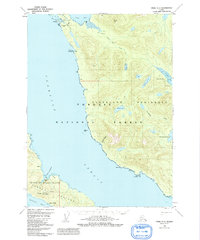
1950 Map of Craig C-1
USGS Topo · Published 1992About this map
Clarence Strait separates the wilderness of the Tongass National Forest on the Cleveland Peninsula from the mineral-rich shores of Prince Of Wales Island. This 1950 survey highlights a coastal landscape defined by industrial extraction and small maritime settlements. On the southern portion of the map, the Kasaan Peninsula is dotted with active and former mining operations including the Mt Andrew Mine, Mamie Mine, and Stevenstown Mine, which were historically vital to the region's copper production. Near the abandoned settlement at Hadley (Site), the map records the infrastructure of the early 20th-century mining boom, while the small community of Meyers Chuck at the northern edge remains a focal point for local fishing and mail service. Numerous cabins and gaging stations scattered along Black Bear Creek and Smugglers Creek reflect a landscape utilized for both resource management and remote subsistence.
Find a feature on this map
37 named features on this map. Tap any name to fly to it.
Don’t see what you’re looking for? This feature index may not catch every label — zoom into the map to look around manually.
Map Details
Editions of this 1950 Craig C-1 Map
4 editions found
Other maps of this area

1949 · Craig C-2
USGS Topo · 1:63,360

1949 · Craig D-2
USGS Topo · 1:63,360

1949 · Craig B-2
USGS Topo · 1:63,360

1949 · Ketchikan C-6
USGS Topo · 1:63,360

1949 · Craig B-1
USGS Topo · 1:63,360

1949 · Craig D-1
USGS Topo · 1:63,360

1950 · Craig B-1
USGS Topo · 1:63,360

1950 · Craig C-1
USGS Topo · 1:63,360

1951 · Craig B-2
USGS Topo · 1:63,360

1951 · Craig D-2
USGS Topo · 1:63,360