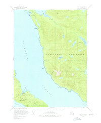
1950 Map of Craig C-1
USGS Topo · Published 1970About this map
Cleveland Peninsula and Prince of Wales Island dominate this 1950 coastal survey, separated by the wide waters of Clarence Strait. The industrial history of the region is evident in the cluster of extractive sites near the southern shore, including the Mamie Mine, Stevenstown Mine, and Mt Andrew. Further north on the peninsula, the Sleeping Beauty Mine and Bert Lide Mine sit tucked between the peaks and Helm Bay. Settlement patterns are sparse, defined by the fishing community at Meyers Chuck and the site of Hadley, which is marked as abandoned by this era. The topography is defined by significant landmarks like South Mtn and the unique drainage of Black Bear Creek, while the shoreline is dotted with maritime points of interest such as Niblack Pt and the sheltered Lyman Anchorage.
Find a feature on this map
33 named features on this map. Tap any name to fly to it.
Don’t see what you’re looking for? This feature index may not catch every label — zoom into the map to look around manually.
Map Details
Editions of this 1950 Craig C-1 Map
4 editions found
Other maps of this area

1949 · Craig C-2
USGS Topo · 1:63,360

1949 · Craig D-2
USGS Topo · 1:63,360

1949 · Craig B-2
USGS Topo · 1:63,360

1949 · Ketchikan C-6
USGS Topo · 1:63,360

1949 · Craig B-1
USGS Topo · 1:63,360

1949 · Craig D-1
USGS Topo · 1:63,360

1950 · Craig B-1
USGS Topo · 1:63,360

1950 · Craig C-1
USGS Topo · 1:63,360

1951 · Craig B-2
USGS Topo · 1:63,360

1951 · Craig D-2
USGS Topo · 1:63,360