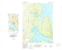
1949 Map of Craig C-2
USGS Topo · Published 1988About this map
Mining operations and remote coastal settlements define this mid-century look at Prince of Wales Island. Centered on the intricate coastline of the Kasaan Peninsula and the reaches of Thorne Bay, the landscape is marked by a legacy of resource extraction, with numerous sites such as the Salt Chuck Mine, Rush and Brown Mine, and Haida Mine dotting the interior. These locations, alongside others like the Poor Man Mine, suggest a period of intense prospecting and geological interest in the Tongass National Forest.
Find a feature on this map
79 named features on this map. Tap any name to fly to it.
Don’t see what you’re looking for? This feature index may not catch every label — zoom into the map to look around manually.
Map Details
Editions of this 1949 Craig C-2 Map
3 editions found
Other maps of this area

1949 · Craig D-3
USGS Topo · 1:63,360

1949 · Craig C-2
USGS Topo · 1:63,360

1949 · Craig D-2
USGS Topo · 1:63,360

1949 · Craig B-2
USGS Topo · 1:63,360

1949 · Craig B-3
USGS Topo · 1:63,360

1949 · Craig C-3
USGS Topo · 1:63,360

1949 · Craig B-1
USGS Topo · 1:63,360

1949 · Craig D-1
USGS Topo · 1:63,360

1950 · Craig D-3
USGS Topo · 1:63,360

1950 · Craig B-1
USGS Topo · 1:63,360