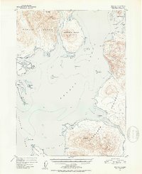
1951 Map of Craig D-1
USGS Topo · Published 1953About this map
Etolin Island and the Cleveland Peninsula dominate this 1951 topographic study of the Alexander Archipelago's intricate waterways. The map records the maritime landscape of the Ernest Sound and Clarence Strait before modern development, detailing the steep topography of Mt Shakes and Mt Burnett.
Find a feature on this map
47 named features on this map. Tap any name to fly to it.
Don’t see what you’re looking for? This feature index may not catch every label — zoom into the map to look around manually.
Map Details
Editions of this 1951 Craig D-1 Map
2 editions found

Other maps of this area

1948 · Petersburg A-1
USGS Topo · 1:63,360

1948 · Petersburg A-2
USGS Topo · 1:63,360

1949 · Craig C-2
USGS Topo · 1:63,360

1949 · Craig D-2
USGS Topo · 1:63,360

1949 · Ketchikan C-6
USGS Topo · 1:63,360

1949 · Craig D-1
USGS Topo · 1:63,360

1950 · Craig C-1
USGS Topo · 1:63,360

1951 · Craig D-2
USGS Topo · 1:63,360

1951 · Bradfield Canal
USGS Topo · 1:250,000

1951 · Craig C-2
USGS Topo · 1:63,360