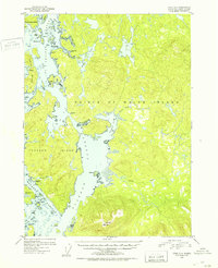
1951 Map of Craig D-4
USGS Topo · Published 1953About this map
El Capitan Passage and the surrounding islands of the Tongass National Forest define this 1951 topographic survey of Southeast Alaska. The map records several sites of former human activity, including the abandoned settlements at Deweyville and Tuxekan, as well as Sarkar Cove. These locations, once centers of coastal life, are depicted alongside active points like Tokeen and Brockman. The terrain is characterized by a complex network of waterways such as Tuxekan Passage and Karheen Passage, separating Tuxekan Island and Heceta I from the western edge of Prince of Wales Island. Notable landmarks like Twin Mtn rise above the coastal flats and numerous inlets, while inland Sarkar Lake and the Karheen Lakes illustrate the region's dense freshwater drainage system. This era of mapping shows the coastal wilderness before modern development, capturing the sparse distribution of Cabins and a Lodge that served early post-war travelers and workers.
Find a feature on this map
52 named features on this map. Tap any name to fly to it.
Don’t see what you’re looking for? This feature index may not catch every label — zoom into the map to look around manually.
Map Details
Editions of this 1951 Craig D-4 Map
2 editions found

Other maps of this area

1949 · Craig D-3
USGS Topo · 1:63,360

1949 · Petersburg A-3
USGS Topo · 1:63,360

1949 · Craig D-4
USGS Topo · 1:63,360

1949 · Petersburg A-5
USGS Topo · 1:63,360

1949 · Petersburg A-4
USGS Topo · 1:63,360

1949 · Craig C-3
USGS Topo · 1:63,360

1949 · Craig C-4
USGS Topo · 1:63,360

1950 · Craig D-3
USGS Topo · 1:63,360

1951 · Craig C-3
USGS Topo · 1:63,360

1951 · Craig C-4
USGS Topo · 1:63,360