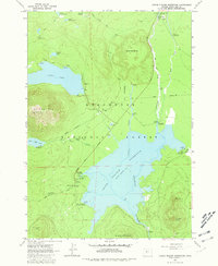
1963 Map of Crane Prairie Reservoir
USGS Topo · Published 1981About this map
Crane Prairie Reservoir dominates this central Oregon landscape, showing the hydrologic management of the upper Deschutes River in the early 1960s. The map illustrates a transitional period for the area's infrastructure, notably marking several segments of the Cascade Lakes Highway as Under Construction. This development reflects the increasing accessibility of the Deschutes National Forest for recreation and resource management. Scattered along the shoreline and deep within the timber are specialized outposts like the Snow Creek Project Camp and the Deschutes Bridge Guard Sta.
Find a feature on this map
42 named features on this map. Tap any name to fly to it.
Don’t see what you’re looking for? This feature index may not catch every label — zoom into the map to look around manually.
Map Details
Editions of this 1963 Crane Prairie Reservoir Map
4 editions found
Other maps of this area

1930 · Maiden Peak
USGS Topo · 1:125,000

1934 · Maiden Peak
USGS Topo · 1:125,000

1955 · Crescent
USGS Topo · 1:250,000

1957 · Crescent
USGS Topo · 1:250,000

1958 · Crescent
USGS Topo · 1:250,000
1963 · Elk Lake
USGS Topo · 1:24,000

1963 · Round Mountain
USGS Topo · 1:24,000
1963 · The Twins
USGS Topo · 1:24,000
1963 · Irish Mountain
USGS Topo · 1:24,000
1963 · Packsaddle Mtn
USGS Topo · 1:24,000