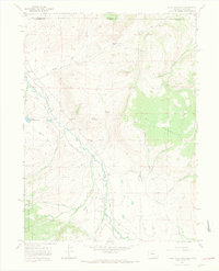
1967 Map of Crazy Mountain
USGS Topo · Published 1971About this map
The Laramie River winds through the borderlands of Colorado and Wyoming in this 1967 survey, where ranching and resource management define the high-altitude landscape. The Geneyre Sch serves as a small social marker of local settlement near the riverbanks, while the intricate network of water management features, such as the La Garde Ditch, Lower La Garde Ditch, and Pache Ditch, reveals the labor required to sustain this arid environment. The terrain is marked by prominent peaks like Crazy Mountain and Bull Mountain, which rise above the western edge of the Roosevelt National Forest.
Find a feature on this map
36 named features on this map. Tap any name to fly to it.
Don’t see what you’re looking for? This feature index may not catch every label — zoom into the map to look around manually.
Map Details
Editions of this 1967 Crazy Mountain Map
2 editions found
Other maps of this area

1895 · Laramie
USGS Topo · 1:125,000

1902 · Laramie
USGS Topo · 1:125,000

1905 · Laramie
USGS Topo · 1:125,000

1906 · Medicine Bow
USGS Topo · 1:125,000

1906 · Laramie
USGS Topo · 1:125,000

1908 · Laramie
USGS Topo · 1:125,000

1908 · Medicine Bow
USGS Topo · 1:125,000

1916 · Home
USGS Topo · 1:125,000

1920 · Home
USGS Topo · 1:125,000

1954 · Cheyenne
USGS Topo · 1:250,000