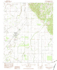
1983 Map of Crenshaw South
USGS Topo · Published 1983About this map
The lowlands of northwestern Mississippi are defined by a complex network of bayous and creeks in this 1983 survey. This landscape, straddling the Quitman Co Panola Co line, centers on the towns of Sledge and Crenshaw, where the Illinois Central Gulf railroad provided a vital corridor for commerce and transport. The terrain is marked by numerous water bodies like Yellow Lake and Pruit Lake, and the dense drainage patterns of Hope Bayou and Pecan Bayou suggest the heavy alluvial nature of the region. Scattered throughout the rural areas are local landmarks that served as community hubs, including Bethel Ch, Phillips Chapel, and Easley Ch. To the south, the wetland environment becomes more pronounced near Chinquapin Brake, illustrating the transition from agricultural tracts to the native brakes and lakes of the Delta region.
Find a feature on this map
31 named features on this map. Tap any name to fly to it.
Don’t see what you’re looking for? This feature index may not catch every label — zoom into the map to look around manually.
Map Details
Editions of this 1983 Crenshaw South Map
This is the sole edition of this map. No revisions or reprints were ever made.
Other maps of this area

1908 · Walnut Lake
USGS Topo · 1:24,000

1910 · Walnut Lake
USGS Topo · 1:31,680

1932 · Sledge
USGS Topo · 1:48,000

1932 · Marks
USGS Topo · 1:48,000

1932 · Crenshaw
USGS Topo · 1:62,500

1935 · Marks
USGS Topo · 1:62,500

1935 · Crenshaw
USGS Topo · 1:62,500

1935 · Sledge
USGS Topo · 1:62,500

1939 · Clayton
USGS Topo · 1:62,500

1939 · Sledge
USGS Topo · 1:62,500