Loading...
Loading map...1963 Map of Crenshaw
USGS Topo · Published 1965About this map
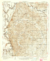
The Arkabutla Lake reservoir dominates the northern landscape of this region, where the hills of Tate County meet the flat alluvial plains of the Mississippi Delta. The Coldwater River and its numerous distributaries, including Cormorant Bayou and Big Bayou, dictate the geography of the western lowlands. This era shows a rural landscape punctuated by dozens of small community centers, often centered on country churches like Hunter Chapel, Antioch Ch No 2, and Brooks Chapel.
Find a feature on this map
89 named features on this map. Tap any name to fly to it.
Don’t see what you’re looking for? This feature index may not catch every label — zoom into the map to look around manually.
Map Details
Date Portrayed1963
Date Published1965
PublisherU.S. Geological Survey
Map TypeTopographic
Scale1:62,500
Physical Dimensions16.9 x 20.8 inches
Editions of this 1963 Crenshaw Map
This is the sole edition of this map. No revisions or reprints were ever made.
Historical Maps of Senatobia Through Time
3 maps found

Featured Locations
Source Details
SourceU.S. Geological Survey
CopyrightPublic Domain