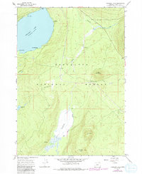
1967 Map of Crescent Lake
USGS Topo · Published 1992About this map
Crescent Lake dominates the northwest corner of this Klamath County landscape, serving as a focal point for recreation and forest management in the mid-1960s. The shoreline reveals several seasonal and organizational sites, including Camp Makualla, the Boy Scout Camp, and Simax Beach Campgrounds near Simax Bay. The geography is defined by volcanic features and significant drainage systems within the Deschutes National Forest, where peaks like Little Odell Butte and Beales Butte rise above the timberline.
Find a feature on this map
22 named features on this map. Tap any name to fly to it.
Don’t see what you’re looking for? This feature index may not catch every label — zoom into the map to look around manually.
Map Details
Editions of this 1967 Crescent Lake Map
3 editions found
Other maps of this area

1917 · Diamond Lake
USGS Topo · 1:125,000

1925 · Waldo Lake
USGS Topo · 1:125,000

1930 · Maiden Peak
USGS Topo · 1:125,000

1934 · Maiden Peak
USGS Topo · 1:125,000

1935 · Chemult
USGS Topo · 1:96,000

1941 · Chemult
USGS Topo · 1:125,000

1955 · Crescent
USGS Topo · 1:250,000

1956 · Waldo Lake
USGS Topo · 1:62,500

1956 · Summit Lake
USGS Topo · 1:62,500

1957 · Crescent
USGS Topo · 1:250,000