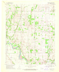
1969 Map of Crescent NW
USGS Topo · Published 1972About this map
The Cimarron River sweeps through the southwest corner of this landscape on the border of Kingfisher and Logan counties. During the late 1960s, this region was defined by the extensive Sooner Trend Oil Field, where numerous wells and pumping stations were interspersed among the section-line roads and agricultural fields. Small rural hubs such as Wandel and the family-named Borelli cluster south of the river, while the northeastern corner is traversed by the Atchison Topeka and Santa Fe railroad line. Local history is anchored by a network of country institutions, including Central Ch, Mount Pleasant Ch, and several community burial grounds like Zion Community Cem and Oak Vale Cem, which reflect the area's established farming and ranching heritage.
Find a feature on this map
25 named features on this map. Tap any name to fly to it.
Don’t see what you’re looking for? This feature index may not catch every label — zoom into the map to look around manually.
Map Details
Editions of this 1969 Crescent NW Map
This is the sole edition of this map. No revisions or reprints were ever made.
Other maps of this area

1892 · Kingfisher
USGS Topo · 1:125,000

1893 · Lovell
USGS Topo · 1:62,500

1893 · Hennessey
USGS Topo · 1:62,500

1895 · Kingfisher
USGS Topo · 1:125,000

1954 · Oklahoma City
USGS Topo · 1:250,000

1955 · Enid
USGS Topo · 1:250,000

1956 · Hennessey
USGS Topo · 1:62,500

1957 · Oklahoma City
USGS Topo · 1:250,000

1958 · Enid
USGS Topo · 1:250,000

1963 · Oklahoma City
USGS Topo · 1:250,000