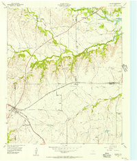
1955 Map of Cresson
USGS Topo · Published 1956About this map
Cresson sits at the junction of five county lines, serving as a vital rail hub where the Gulf Colorado and Santa Fe (AT & SF) railroad bifurcates the landscape. This mid-1950s survey captures the area during the early years of Benbrook Lake, showing the reservoir's northern reach where the Clear Fork Trinity River enters. The map is particularly rich for genealogical research, documenting several rural burial grounds including Keyes Cem, Corn Cem, and the Day-Radcliff Cemetery along the winding course of South Bear Creek. Small communities like Wheatland and Winscott appear with their local landmarks, such as the Wheatland Sch, while the presence of several Gravel Pits and a Quarry point to the local extractive industry that supported North Texas growth during this era.
Find a feature on this map
27 named features on this map. Tap any name to fly to it.
Don’t see what you’re looking for? This feature index may not catch every label — zoom into the map to look around manually.
Map Details
Editions of this 1955 Cresson Map
Other maps of this area

1889 · Granbury
USGS Topo · 1:125,000

1891 · Weatherford
USGS Topo · 1:125,000

1891 · Cleburne
USGS Topo · 1:125,000

1893 · Weatherford
USGS Topo · 1:125,000

1894 · Cleburne
USGS Topo · 1:125,000

1894 · Fort Worth
USGS Topo · 1:125,000

1923 · Granbury 1-b
USGS Topo · 1:48,000

1928 · Godley
USGS Topo · 1:62,500

1954 · Dallas
USGS Topo · 1:250,000

1955 · Aledo
USGS Topo · 1:24,000