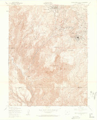
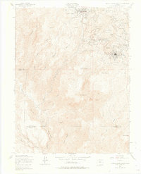
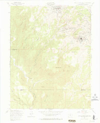
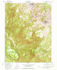
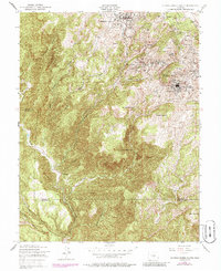
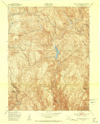
1951 Map of Cripple Creek South
USGS Topo · Published 1962About this map
The high-elevation gold mining district of Colorado is captured here in 1951, showing the dense industrial network surrounding Cripple Creek and Victor. This landscape is defined by the subterranean economy, with the massive Carlton Tunnel and Roosevelt Tunnel cutting beneath the peaks of Squaw Mountain and Grouse Mountain. The map reveals the proximity of numerous independent mining operations, including the Golden Cycle Mine, Cresson Mine, and Stratton Mine, which once made this region one of the most productive gold fields in the world. Settlements like Altman, Elkton, and Goldfield are shown in their post-war state, while the rugged drainage systems of Poverty Gulch and Arequa Gulch provide the topographic context for the district's development. Local history is further grounded by the inclusion of the Mt Pisgah Cemetery and Victor Cem, documenting the human toll of the era's intensive hard-rock mining.
Find a feature on this map
65 named features on this map. Tap any name to fly to it.
Don’t see what you’re looking for? This feature index may not catch every label — zoom into the map to look around manually.
Map Details
Editions of this 1951 Cripple Creek South Map
9 editions found
Other maps of this area

1894 · Pikes Peak
USGS Topo · 1:125,000

1901 · Pikes Peak
USGS Topo · 1:125,000

1901 · Pikes Peak
USGS Topo · 1:62,500

1942 · Cover Mtn.
USGS Topo · 1:62,500

1948 · Cover Mtn.
USGS Topo · 1:62,500

1951 · Cripple Creek South
USGS Topo · 1:24,000
1951 · Big Bull Mountain
USGS Topo · 1:24,000

1951 · Pikes Peak
USGS Topo · 1:24,000

1951 · Cripple Creek North
USGS Topo · 1:24,000
1954 · Phantom Canyon
USGS Topo · 1:24,000