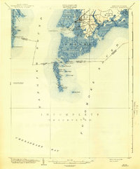
1903 Map of Crisfield
USGS Topo · Published 1942About this map
The maritime hub of Crisfield serves as the focal point of this coastal survey, where the N. Y. P. and N. R. R. terminates at the water's edge, signaling the town's importance as a transfer point for seafood and freight. Surrounding the main settlement are smaller communities like Lawsonia, Shokertown, and Birdtown, all deeply integrated into the marshy geography of Asbury and Lawsons. The map reveals a complex network of waterways, including the Little Annemessex River and Somers Cove, which support the region's historical reliance on the bay.
Find a feature on this map
58 named features on this map. Tap any name to fly to it.
Don’t see what you’re looking for? This feature index may not catch every label — zoom into the map to look around manually.
Map Details
Editions of this 1903 Crisfield Map
4 editions found
Other maps of this area

1898 · St. Marys
USGS Topo · 1:125,000

1903 · Crisfield
USGS Topo · 1:62,500

1903 · Bloodsworth Island
USGS Topo · 1:62,500

1903 · Deal Island
USGS Topo · 1:62,500

1906 · St. Marys
USGS Topo · 1:125,000

1917 · Ewell
USGS Topo · 1:62,500

1920 · Crisfield
USGS Topo · 1:62,500

1931 · Accomac
USGS Topo · 1:48,000

1935 · Accomac
USGS Topo · 1:62,500

1942 · Chesconessex
USGS Topo · 1:31,680