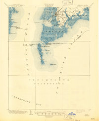
1903 Map of Crisfield
USGS Topo · Published 1945About this map
Crisfield stands as the primary hub of this coastal survey, where the N and W R R terminates at the water's edge, signaling the town’s era as a vital seafood processing and shipping center. The intricate shoreline of the Annemessex River and Little Annemessex River reveals a landscape defined by waterborne trade and maritime navigation, marked by the Janes Island L.H. and Somers Cove L.H. beacons. To the west, the isolated community of Horse Hammock on Smith Island illustrates the specialized island life of the Chesapeake Bay, where settlements like Sackertown, Lawsonia, and Birdtown are deeply integrated with the marshy estuaries. The southern portion of the map remains noted as incomplete (unsurveyed), emphasizing the challenges of mapping the shifting shoals and complex tidal guts of Tangier Sound and Pocomoke Sound during the early 1900s.
Find a feature on this map
59 named features on this map. Tap any name to fly to it.
Don’t see what you’re looking for? This feature index may not catch every label — zoom into the map to look around manually.
Map Details
Editions of this 1903 Crisfield Map
4 editions found
Other maps of this area

1898 · St. Marys
USGS Topo · 1:125,000

1903 · Crisfield
USGS Topo · 1:62,500

1903 · Bloodsworth Island
USGS Topo · 1:62,500

1903 · Deal Island
USGS Topo · 1:62,500

1906 · St. Marys
USGS Topo · 1:125,000

1917 · Ewell
USGS Topo · 1:62,500

1920 · Crisfield
USGS Topo · 1:62,500

1931 · Accomac
USGS Topo · 1:48,000

1935 · Accomac
USGS Topo · 1:62,500

1942 · Chesconessex
USGS Topo · 1:31,680