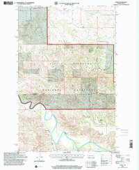
1997 Map of Croff
USGS Topo · Published 2001About this map
The Little Missouri River carves a deep, winding path through the heart of this landscape, marking the transition between the plains and the broken badlands terrain. Established ranching operations like the D Rink Ranch, Fenton Ranch, and Jorgenson Ranch define the land use, reflecting a legacy of hardy frontier agriculture within the Little Missouri National Grassland. The small settlement of Croff and the nearby Croff Sch serve as quiet reminders of the rural community structures that supported families along the northern edge of the Bear Den uplands. Water remains the primary shaper of the map, from the major drainage of Beaver Creek and Bear Creek to isolated landmarks like the Flowing Well. This survey reveals the sparse, high-plains geography where the McKenzie and Dunn County line crosses through open range and narrow creek valleys.
Find a feature on this map
15 named features on this map. Tap any name to fly to it.
Don’t see what you’re looking for? This feature index may not catch every label — zoom into the map to look around manually.
Map Details
Editions of this 1997 Croff Map
This is the sole edition of this map. No revisions or reprints were ever made.
Other maps of this area

1953 · Watford City
USGS Topo · 1:250,000

1957 · Watford City
USGS Topo · 1:250,000

1958 · Lone Butte SE
USGS Topo · 1:24,000

1958 · North Killdeer Mountain
USGS Topo · 1:24,000

1959 · Croff
USGS Topo · 1:24,000

1959 · Lone Butte NE
USGS Topo · 1:24,000

1965 · Johnsons Corner
USGS Topo · 1:24,000

1965 · Blue Buttes SE
USGS Topo · 1:24,000

1967 · Watford City
USGS Topo · 1:250,000

1970 · Lost Bridge
USGS Topo · 1:24,000