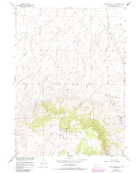
1951 Map of Crooks Mountain
USGS Topo · Published 1985About this map
The Happy Springs Oil Field and the Crooks Gap Oil Field dominate this mid-century survey of the Wyoming high desert, reflecting the intensive energy development in Fremont County during the post-war era. The landscape is defined by the high ridge of Crooks Mountain, where numerous Oil Wells and a complex network of infrastructure, including a Pipe Line and a dedicated Telephone Line, intersect the natural drainages of Haypress Creek and Nancy Creek. For the researcher, the map reveals the industrial footprint of the petroleum boom, showing how roads and facilities were carved into the terrain surrounding Boggy Springs Pond and Woods Gulch Pond. This 1951 record captures the specific moment when exploration was reshaping the Missouri River Basin's resource frontier.
Find a feature on this map
14 named features on this map. Tap any name to fly to it.
Don’t see what you’re looking for? This feature index may not catch every label — zoom into the map to look around manually.
Map Details
Editions of this 1951 Crooks Mountain Map
4 editions found
Other maps of this area

1951 · Soap Holes
USGS Topo · 1:24,000

1951 · Crooks Creek NE
USGS Topo · 1:24,000

1951 · Stampede Meadow
USGS Topo · 1:24,000

1951 · Graham Ranch
USGS Topo · 1:24,000

1951 · Crooks Mountain
USGS Topo · 1:24,000

1951 · Myers Ranch
USGS Topo · 1:24,000

1955 · Lander
USGS Topo · 1:250,000

1955 · Casper
USGS Topo · 1:250,000

1957 · Jeffrey City
USGS Topo · 1:24,000

1958 · Casper
USGS Topo · 1:250,000