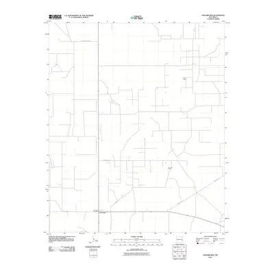
2010 Map of Crossroads
USGS Topo · Published 2010About this map
Crossroads stands as the central hub of this eastern New Mexico landscape, situated at the junction of several arterial routes during the first decade of the 21st century. The presence of the Crossroads Post Office anchors this small settlement as a vital point of contact for the surrounding ranching and energy-producing lands. The map highlights a rural infrastructure defined by an extensive grid of local routes, including S Roosevelt Road 44 and County Rd-175, which connect the community to nearby operations. The economy of the region is grounded in subterranean resources, evidenced by the Prairie Oil Field to the northeast and the Bough Oil Field to the southeast. These features suggest a landscape where energy extraction and transit intersect, maintaining a quiet but essential role in the state's industrial geography.
Find a feature on this map
9 named features on this map. Tap any name to fly to it.
Don’t see what you’re looking for? This feature index may not catch every label — zoom into the map to look around manually.
Map Details
Editions of this 2010 Crossroads Map
This is the sole edition of this map. No revisions or reprints were ever made.
Other maps of this area

1954 · Brownfield
USGS Topo · 1:250,000

1958 · Brownfield
USGS Topo · 1:250,000

1961 · Johnson Ranch
USGS Topo · 1:24,000

1962 · Brownfield
USGS Topo · 1:250,000

1970 · Walking Cane Ranch
USGS Topo · 1:24,000

1970 · Johnson Ranch
USGS Topo · 1:24,000

1970 · Ranger Lake
USGS Topo · 1:24,000

1972 · Milnesand SW
USGS Topo · 1:24,000

1972 · Bluit
USGS Topo · 1:24,000
1972 · Bledsoe SW
USGS Topo · 1:24,000