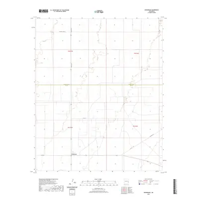
2020 Map of Crossroads
USGS Topo · Published 2020About this map
Crossroads sits near the southern edge of this West Texas borderlands survey, marking a distinct intersection of rural transit in the Llano Estacado region. The landscape is defined by the significant boundary line of Roosevelt Co Lea Co, where township and range lines like t9s r35e and t8s r36e organize the wide-open high plains. A network of county roads, including Co Rd 182 and Co Rd 170, extends across the flat terrain, connecting remote ranching and agricultural tracts. Modern transit is anchored by Dora Main St and Crossroads Rd, reflecting the sparse but enduring settlement patterns of eastern New Mexico. This map reveals the transition between county jurisdictions and the geometric precision of the Public Land Survey System in an area where the horizon is the most prominent feature.
Find a feature on this map
12 named features on this map. Tap any name to fly to it.
Don’t see what you’re looking for? This feature index may not catch every label — zoom into the map to look around manually.
Map Details
Editions of this 2020 Crossroads Map
This is the sole edition of this map. No revisions or reprints were ever made.
Other maps of this area

1954 · Brownfield
USGS Topo · 1:250,000

1958 · Brownfield
USGS Topo · 1:250,000

1961 · Johnson Ranch
USGS Topo · 1:24,000

1962 · Brownfield
USGS Topo · 1:250,000

1970 · Walking Cane Ranch
USGS Topo · 1:24,000

1970 · Johnson Ranch
USGS Topo · 1:24,000

1970 · Ranger Lake
USGS Topo · 1:24,000

1972 · Milnesand SW
USGS Topo · 1:24,000

1972 · Bluit
USGS Topo · 1:24,000
1972 · Bledsoe SW
USGS Topo · 1:24,000