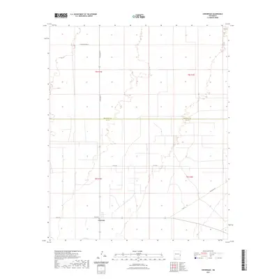
2023 Map of Crossroads
USGS Topo · Published 2023About this map
The settlement of Crossroads sits near the southern edge of this survey on the border of the Llano Estacado. Located just north of the community is Jenkins Cem, a significant landmark for those tracing local family history in this corner of the High Plains. The landscape is characterized by a precise grid of rural routes, including Dora Main St and S Roosevelt Road 44, which mark the transition across the Roosevelt Co Lea Co line.
Find a feature on this map
13 named features on this map. Tap any name to fly to it.
Don’t see what you’re looking for? This feature index may not catch every label — zoom into the map to look around manually.
Map Details
Editions of this 2023 Crossroads Map
This is the sole edition of this map. No revisions or reprints were ever made.
Other maps of this area

1954 · Brownfield
USGS Topo · 1:250,000

1958 · Brownfield
USGS Topo · 1:250,000

1961 · Johnson Ranch
USGS Topo · 1:24,000

1962 · Brownfield
USGS Topo · 1:250,000

1970 · Walking Cane Ranch
USGS Topo · 1:24,000

1970 · Johnson Ranch
USGS Topo · 1:24,000

1970 · Ranger Lake
USGS Topo · 1:24,000

1972 · Milnesand SW
USGS Topo · 1:24,000

1972 · Bluit
USGS Topo · 1:24,000
1972 · Bledsoe SW
USGS Topo · 1:24,000