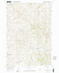
1967 Map of Crow Agency SE
USGS Topo · Published 1970About this map
Custer Battlefield National Monument (Reno-Benteen Battle Site) dominates the southwestern portion of this landscape, marking the historic ground above the Little Bighorn River. The topography is defined by a series of deep drainages and ridges, including Medicine Tail Coulee and North Fork Reno Creek, which were instrumental in the maneuvers during the 1876 battle. Outside of the monument boundaries, the map reveals a mid-century Montana ranching landscape characterized by isolated improvements like the Cannery Landing Strip and numerous seasonal water sources such as Willow Creek and Ash Creek. The intricate contour lines illustrate the broken terrain of the Crow Indian Reservation, showing how modern access roads and fences navigate the same coulees and divides that shaped the area's 19th-century history. This survey provides a precise look at the land's physical layout just before the battlefield was renamed in the 1990s.
Find a feature on this map
10 named features on this map. Tap any name to fly to it.
Don’t see what you’re looking for? This feature index may not catch every label — zoom into the map to look around manually.
Map Details
Editions of this 1967 Crow Agency SE Map
3 editions found
Other maps of this area

1894 · Rosebud
USGS Topo · 1:125,000

1901 · Rosebud
USGS Topo · 1:125,000

1954 · Hardin
USGS Topo · 1:250,000

1957 · Hardin
USGS Topo · 1:250,000

1958 · Hardin
USGS Topo · 1:250,000

1967 · Jeans Fork NW
USGS Topo · 1:24,000

1967 · Crow Agency NE
USGS Topo · 1:24,000

1967 · Crow Agency SE
USGS Topo · 1:24,000

1967 · Lodge Grass NE
USGS Topo · 1:24,000
1967 · Benteen
USGS Topo · 1:24,000