
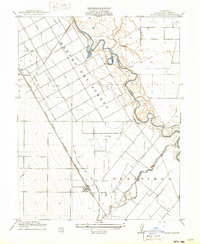
1916 Map of Crows Landing
USGS Topo · Published 1916About this map
The San Joaquin River meanders through the heart of the Central Valley in this 1914 survey, defining a landscape at the height of its early agricultural transformation. The influence of Spanish and Mexican land grants persists through the sprawling Rancho Del Puerto, while the newer mechanical geometry of irrigation begins to reshape the terrain. The San Joaquin and Kings River Irrigation Company Canal and a network of laterals provide the water necessary for the region's transition into a farming powerhouse.
Find a feature on this map
13 named features on this map. Tap any name to fly to it.
Don’t see what you’re looking for? This feature index may not catch every label — zoom into the map to look around manually.
Map Details
Editions of this 1916 Crows Landing Map
2 editions found
Other maps of this area

1915 · Westport
USGS Topo · 1:31,680

1915 · Westley
USGS Topo · 1:31,680

1916 · Mitchell School
USGS Topo · 1:31,680

1916 · Patterson
USGS Topo · 1:31,680

1916 · Ceres
USGS Topo · 1:31,680

1917 · Newman
USGS Topo · 1:31,680

1918 · Gustine
USGS Topo · 1:31,680

1919 · Orestimba
USGS Topo · 1:62,500

1919 · Orestimba Creek
USGS Topo · 1:31,680

1939 · Modesto East
USGS Topo · 1:62,500