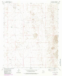
1973 Map of Culp Ranch
USGS Topo · Published 1985About this map
Culp Ranch serves as a primary human anchor in this high desert landscape of Chaves County, where water management defines every mile of the survey. The terrain is characterized by the presence of Shifting Sand, a dynamic environmental feature that underscores the arid conditions of the region. To support livestock and limited habitation, a network of infrastructure is visible, including named water sources like Adams Tank and multiple instances of a Water Tank scattered across the land.
Find a feature on this map
9 named features on this map. Tap any name to fly to it.
Don’t see what you’re looking for? This feature index may not catch every label — zoom into the map to look around manually.
Map Details
Editions of this 1973 Culp Ranch Map
2 editions found
Other maps of this area

1949 · Sardine Mountain
USGS Topo · 1:24,000

1949 · Malstrom Ranch
USGS Topo · 1:24,000

1952 · Connor Well
USGS Topo · 1:24,000

1954 · Brownfield
USGS Topo · 1:250,000

1955 · Roswell
USGS Topo · 1:250,000

1958 · Brownfield
USGS Topo · 1:250,000

1958 · Roswell
USGS Topo · 1:250,000

1962 · Roswell
USGS Topo · 1:250,000

1962 · Brownfield
USGS Topo · 1:250,000

1973 · Culp Ranch
USGS Topo · 1:24,000