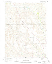
1956 Map of Curtis NW
USGS Topo · Published 1977About this map
Medicine Creek and its complex network of seasonal drainages dominate this mid-century survey of the Frontier and Lincoln County line. The Chicago Burlington and Quincy railroad cuts a diagonal path across the northern landscape, connecting the small community of Wellfleet to the surrounding prairie. This area, mapped for the development of the Missouri River Basin, reveals a transition from the broad canyon bottoms of Lake Canyon and Hay Canyon to the dissected uplands of the Medicine and Laird districts. To the southeast, the settlement of Maywood serves as a local hub near the confluence of several branches of Brushy Cr. Notable water features like Opal Springs and Farmers Lake provide rare reliable water sources in a landscape defined by sharp topographic relief and a dense system of tributary draws including North Brushy Creek and South Brushy Creek.
Find a feature on this map
17 named features on this map. Tap any name to fly to it.
Don’t see what you’re looking for? This feature index may not catch every label — zoom into the map to look around manually.
Map Details
Editions of this 1956 Curtis NW Map
3 editions found
Other maps of this area

1954 · McCook
USGS Topo · 1:250,000

1956 · White NE
USGS Topo · 1:24,000

1956 · Curtis SW
USGS Topo · 1:24,000

1956 · Curtis NW
USGS Topo · 1:24,000

1956 · Curtis
USGS Topo · 1:24,000

1956 · Somerset
USGS Topo · 1:24,000

1956 · Curtis SE
USGS Topo · 1:24,000

1956 · Wellfleet SE
USGS Topo · 1:24,000

1956 · Wellfleet
USGS Topo · 1:24,000

1957 · McCook
USGS Topo · 1:250,000